| Product Image |
Resource Name- |
Price |
Manufacturer |
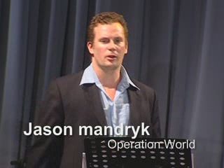 |
·Type: Maps ·Description: Jason Mandryk's State of the Gospel presentation from the 2006 Younger Leader's Gathering (YLG) in Malysia. Video, Audio, and PowerPoint versions of the presentation are available. ·Date: 2006 ·Presenter: Jason Mandryk ·Producer: Harvest Media Ministries·Duration (H:M:S): 36:00 ·Play audio: Your browser does not support the audio element. ·Resolution: Low-320x240 High-640x480 ·Categories: Type :: Maps... |
... more info
Max: 1
|
|
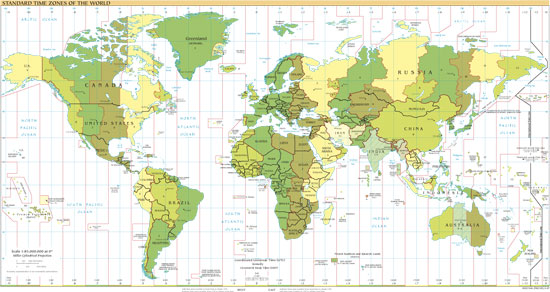 |
·Type: Maps ·Map Date: 2007 ·Producer: US Government ·Collection: World Factbook reference maps ·Size: 550x292 px, landscape ·Categories: Type :: Maps Collection :: World Factbook reference maps Continent/Region :: World Partners :: U.S. Government |
... more info
Max: 1
|
|
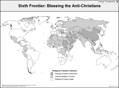 |
·Type: Maps ·Description: Blessing the Anti--Christians is the Sixth Frontier ·Map Date: 2002 ·Producer: Global Mapping International ·Collection: Omega Model of Mission (WV 2002) ·Size: 8½ x 11 Inches, landscape ·Categories: Type :: Maps Collection :: GMI Map Collections :: Omega Model of Mission (WV 2002) Continent/Region :: World Topic :: Strategy Topic :: Concepts Partners :: Global Mapping International |
... more info
Max: 1
|
|
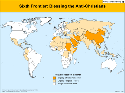 |
·Type: Maps ·Description: Blessing the Anti--Christians is the Sixth Frontier ·Map Date: 1999 ·Producer: Global Mapping International ·Collection: Omega Model of Mission (WV 2002) ·Size: 8½ x 11 Inches, landscape ·Categories: Type :: Maps Collection :: GMI Map Collections :: Omega Model of Mission (WV 2002) Continent/Region :: World Topic :: Strategy Topic :: Concepts Partners :: Global Mapping International |
... more info
Max: 1
|
|
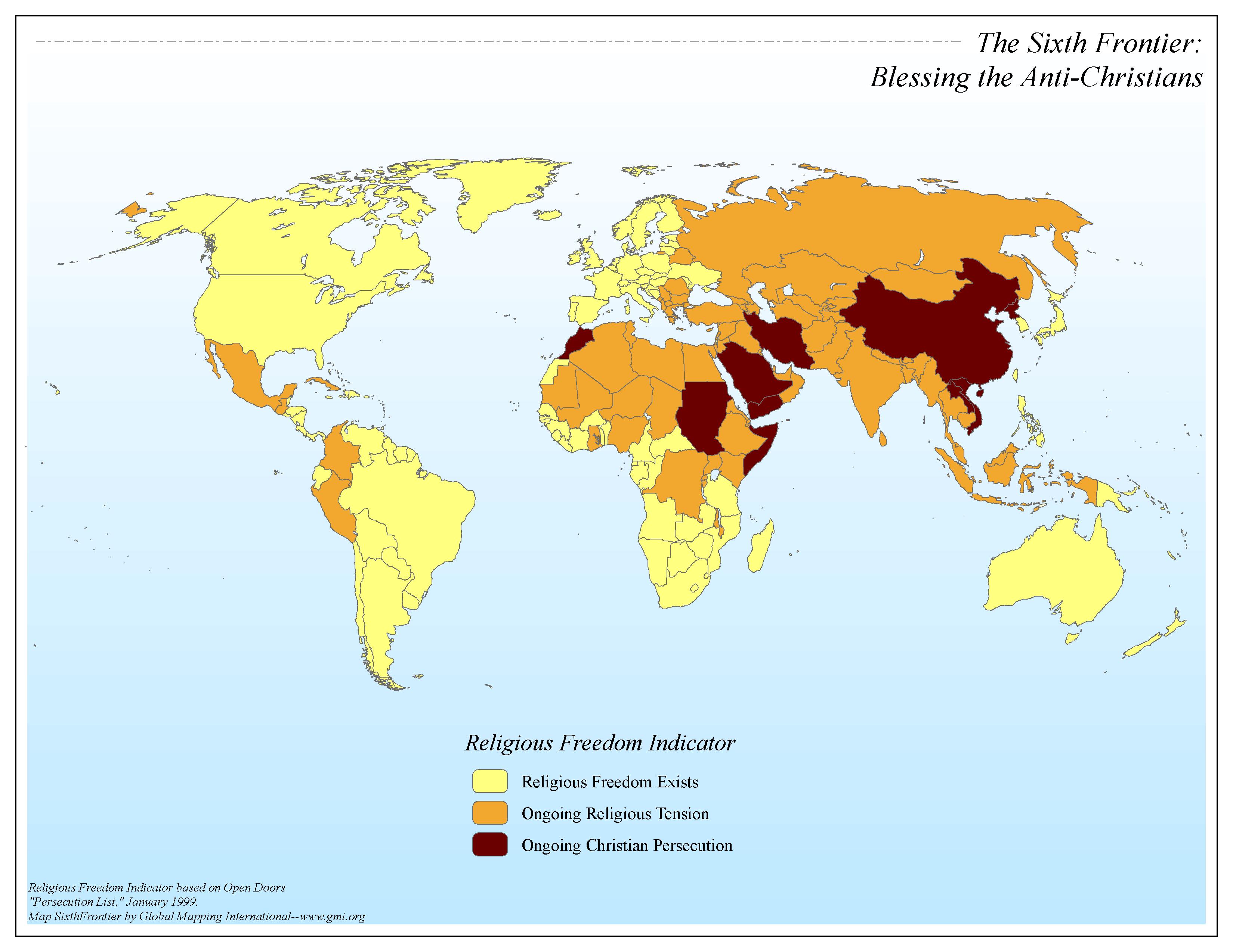 |
·Type: Maps ·Map Date: 2006 ·Data Source: Religious Freedom Indicator based on Open Doors "Persecution List," January 1999. ·Producer: Global Mapping International ·Collection: Omega Model of Mission GMMS 2007 ·Size: 8½ x 11 inches, landscape ·Categories: Type :: Maps Continent/Region :: World Topic :: Strategy Topic :: Concepts Collection :: GMI Map Collections :: Omega Model of Mission GMMS 2007 Partners :: Global Mapping International |
... more info
Max: 1
|
|
 |
·Description: Awakening the Church-Oriented is the Second Frontier ·Map Date: 2002 ·Producer: Global Mapping International ·Collection: Omega Model of Mission (WV 2002) ·Size: 8½ x 11 Inches, landscape ·Categories: Collection :: GMI Map Collections :: Omega Model of Mission (WV 2002) Continent/Region :: World Topic :: Strategy Topic :: Concepts Topic :: Peoples, multiple or unknown Partners :: Global Mapping International |
... more info
Max: 1
|
|
 |
·Type: Maps ·Description: Awakening the Church-Oriented is the Second Frontier ·Map Date: 1999 ·Producer: Global Mapping International ·Collection: Omega Model of Mission (WV 2002) ·Size: 8½ x 11 Inches, landscape ·Categories: Type :: Maps Collection :: GMI Map Collections :: Omega Model of Mission (WV 2002) Continent/Region :: World Topic :: Strategy Topic :: Concepts Topic :: Peoples, multiple or unknown Partners :: Global Mapping... |
... more info
Max: 1
|
|
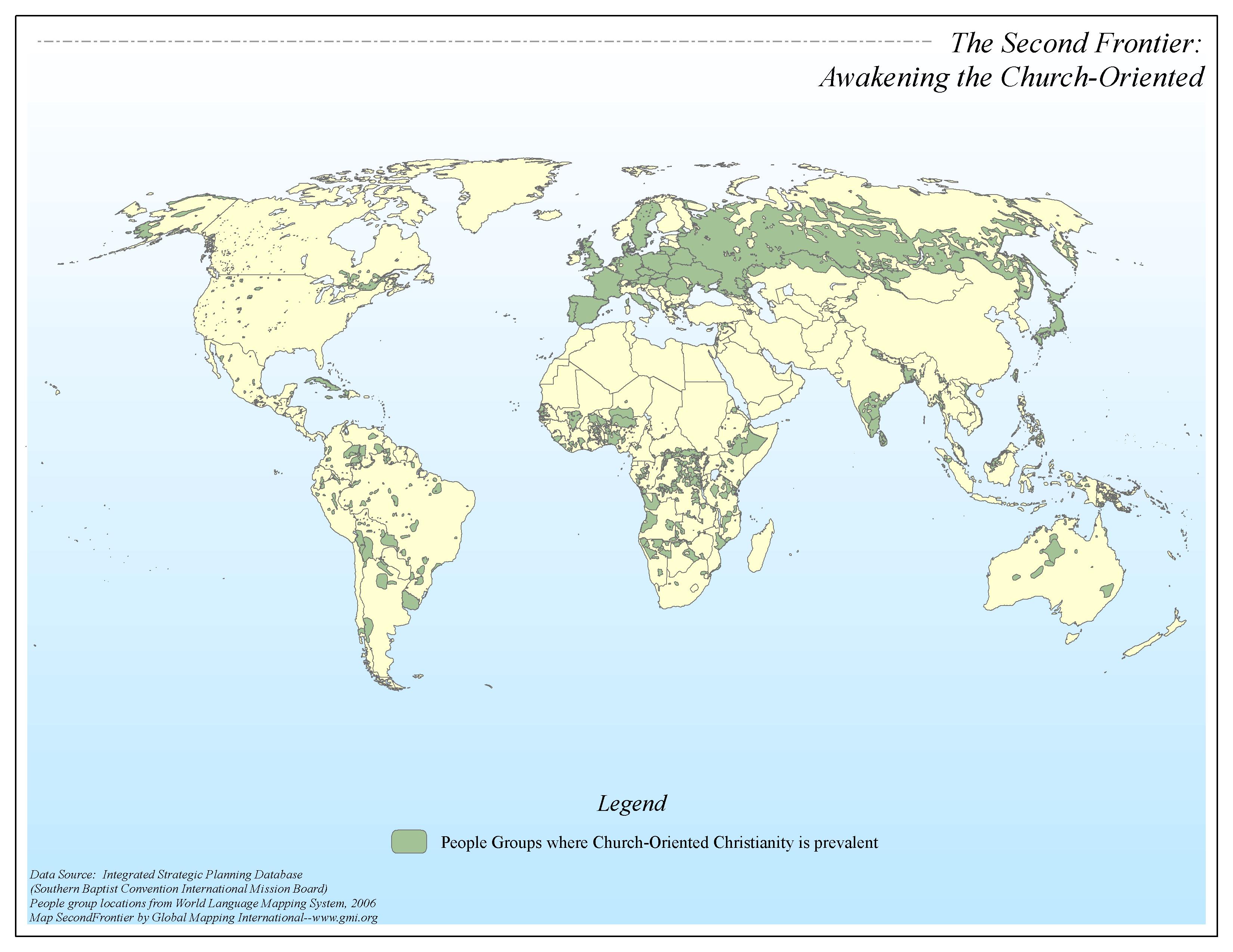 |
·Type: Maps ·Map Date: 2006 ·Data Source: Integrated Strategic Planning Database (SBC-IMB) People group locations from World Language Mapping System, 2006 ·Producer: Global Mapping International ·Collection: Omega Model of Mission GMMS 2007 ·Size: 8½ x 11 inches, landscape ·Categories: Type :: Maps Continent/Region :: World Topic :: Strategy Topic :: Concepts Collection :: GMI Map Collections :: Omega Model of Mission GMMS 2007 Partners... |
... more info
Max: 1
|
|
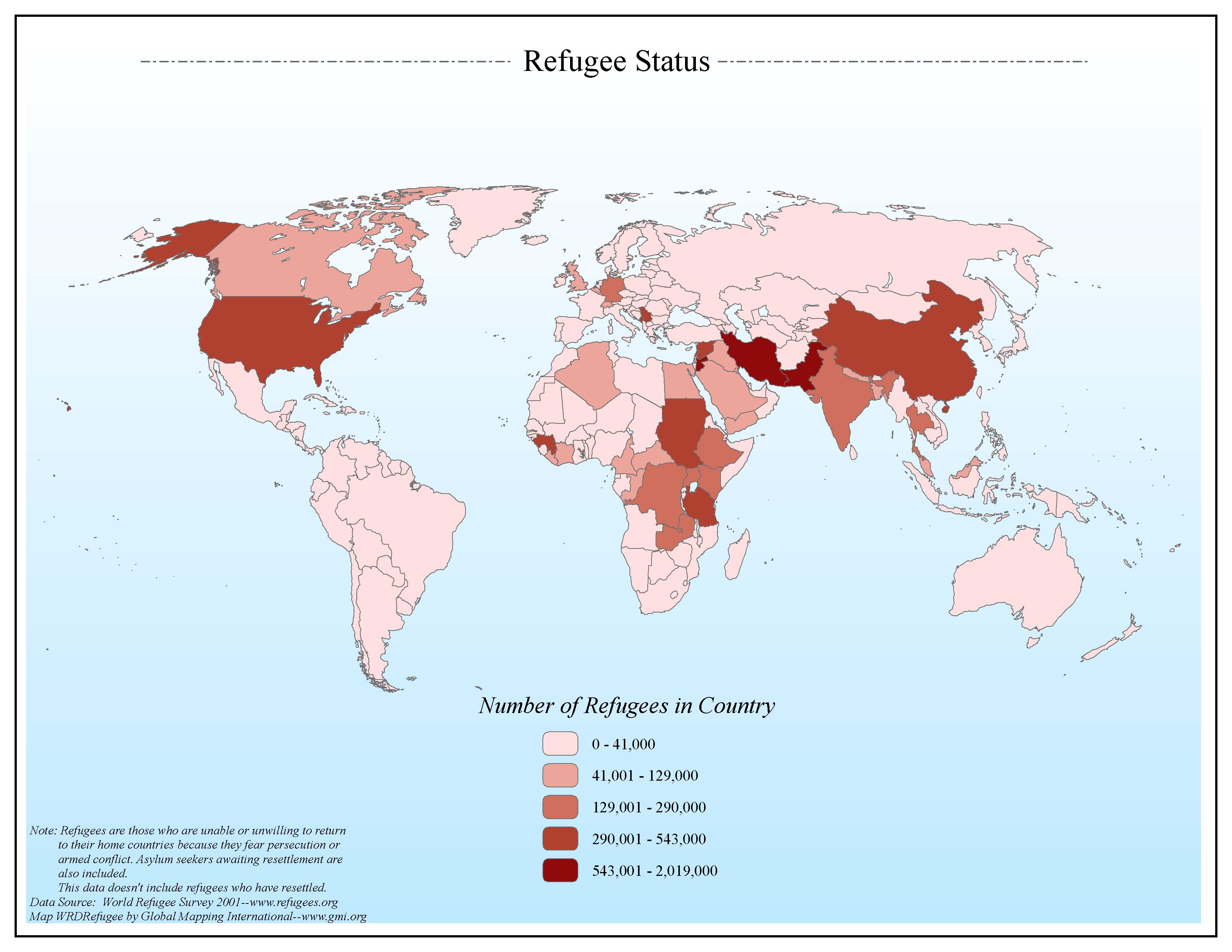 |
·Type: Maps ·Map Date: 2006 ·Data Source: World Refugee Survey 2001--www.refugees.org ·Producer: Global Mapping International ·Collection: General World Maps (GMMS 2007) ·Size: 8½ x 11 inches, landscape ·Categories: Type :: Maps Continent/Region :: World Topic :: Statistical Topic :: Social Collection :: GMI Map Collections :: General World Maps (GMMS 2007) Partners :: Global Mapping International |
... more info
Max: 1
|
|
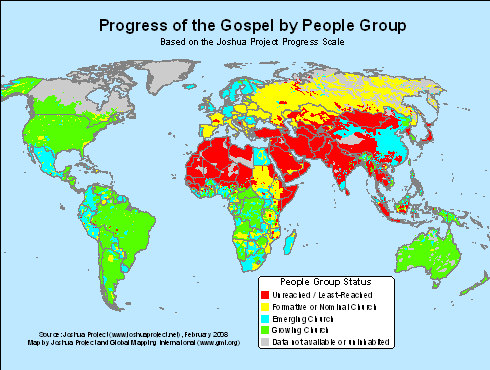 |
·Type: Maps ·Map Date: 2008 ·Data Source: The Joshua Project, February 2008 ·Producer: GMI; The Joshua Project ·Collection: Projects 2008 ·Categories: Type :: Maps Continent/Region :: World Topic :: Strategy Topic :: Peoples, multiple or unknown Partners :: Global Mapping International Collection :: GMI Map Collections :: Projects 2008 Partners :: Joshua Project |
... more info
Max: 1
|
|
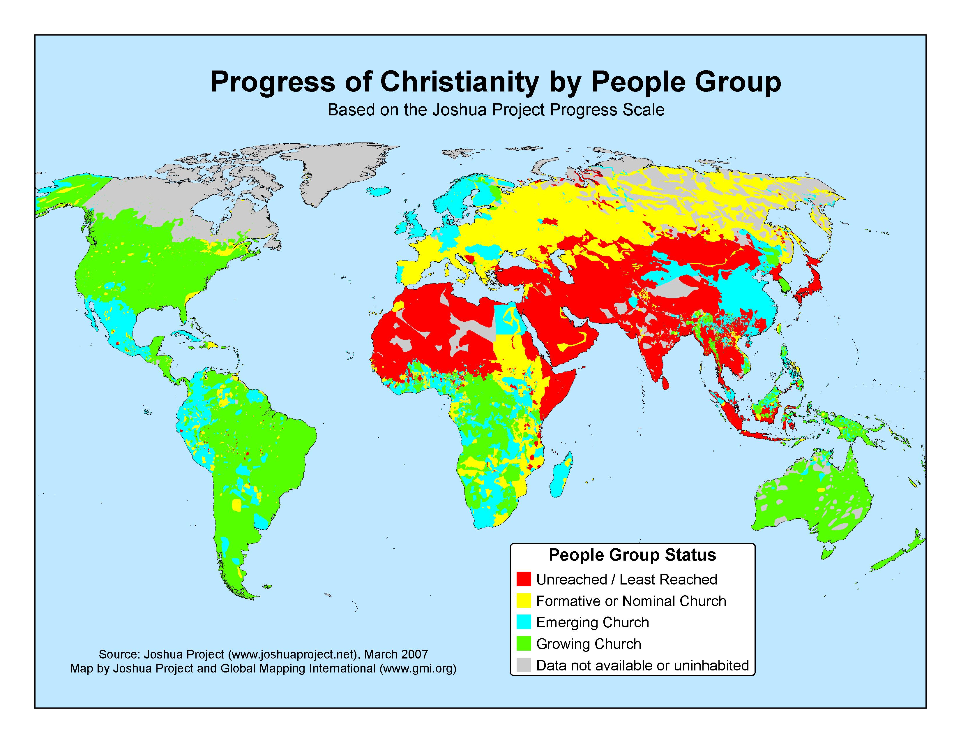 |
·Type: Maps ·Map Date: 2007 ·Data Source: The Joshua Project, March 2007 ·Producer: GMI; The Joshua Project ·Collection: Projects 2007 ·Categories: Type :: Maps Continent/Region :: World Topic :: Statistical Topic :: Peoples, multiple or unknown Partners :: Global Mapping International Collection :: GMI Map Collections :: Projects 2007 Partners :: Joshua Project |
... more info
Max: 1
|
|
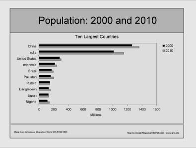 |
·Type: Maps ·Description: Ten Largest contries in 2000 and 2010 ·Map Date: 2002 ·Producer: Global Mapping International ·Collection: Intro to Mission (WorldVue 2002) ·Size: 8½ x 11 Inches, landscape ·Categories: Type :: Maps Collection :: GMI Map Collections :: Intro to Mission (WorldVue 2002) Continent/Region :: World Topic :: Demography Type :: Graphs Partners :: Global Mapping International |
... more info
Max: 1
|
|
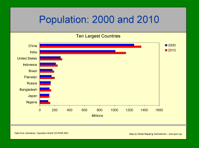 |
·Type: Maps ·Description: Ten Largest contries in 2000 and 2010 ·Map Date: 2001 ·Producer: Global Mapping International ·Collection: Intro to Mission (WorldVue 2002) ·Size: 8½ x 11 Inches, landscape ·Categories: Type :: Maps Collection :: GMI Map Collections :: Intro to Mission (WorldVue 2002) Continent/Region :: World Topic :: Demography Type :: Graphs Partners :: Global Mapping International |
... more info
Max: 1
|
|
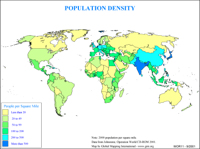 |
·Type: Maps ·Description: Country level distribution of Population density in 2000 (in miles ·Map Date: 2000 ·Producer: Global Mapping International ·Collection: General World Maps (WV 2002) ·Size: 8½ x 11 Inches, landscape ·Categories: Type :: Maps Collection :: GMI Map Collections :: General World Maps (WV 2002) Continent/Region :: World Topic :: Demography Partners :: Global Mapping International |
... more info
Max: 1
|
|
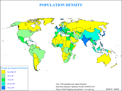 |
·Type: Maps ·Description: Country level distribution of Population density in 2000 (in kilom ·Map Date: 2000 ·Producer: Global Mapping International ·Collection: General World Maps (WV 2002) ·Size: 8½ x 11 Inches, landscape ·Categories: Type :: Maps Collection :: GMI Map Collections :: General World Maps (WV 2002) Continent/Region :: World Topic :: Demography Partners :: Global Mapping International |
... more info
Max: 1
|
|
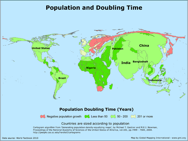 |
· Type: Maps · Map Date: 2011 · Data Source: World Factbook 2010 · Partners: GMI · Collection: Projects 2011 · Size: 8½ x 11 inches, landscape · Categories: Type :: Maps Continent/Region :: World Topic :: Statistical Topic :: Demographic Partners :: Global Mapping International |
... more info
|
|
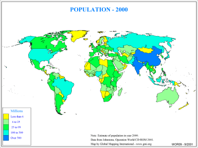 |
·Type: Maps ·Description: Country level distribution of Population in 2000 ·Map Date: 2000 ·Producer: Global Mapping International ·Collection: General World Maps (WV 2002) ·Size: 8½ x 11 Inches, landscape ·Categories: Type :: Maps Collection :: GMI Map Collections :: General World Maps (WV 2002) Continent/Region :: World Topic :: Demography Partners :: Global Mapping International |
... more info
Max: 1
|
|
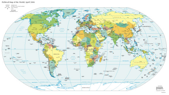 |
·Type: Maps ·Map Date: 2007 ·Producer: US Government ·Collection: World Factbook reference maps ·Size: 579x327 px, landscape ·Categories: Type :: Maps Collection :: World Factbook reference maps Continent/Region :: World Partners :: U.S. Government |
... more info
Max: 1
|
|
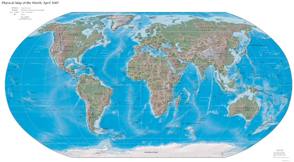 |
·Type: Maps ·Map Date: 2007 ·Producer: US Government ·Collection: World Factbook reference maps ·Size: 578x319 px, landscape ·Categories: Type :: Maps Collection :: World Factbook reference maps Continent/Region :: World Partners :: U.S. Government |
... more info
Max: 1
|
|
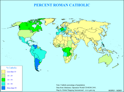 |
·Type: Maps ·Description: Country level divisions of the percent Roman Catholic ·Map Date: 2000 ·Producer: Global Mapping International ·Collection: General World Maps (WV 2002) ·Size: 8½ x 11 Inches, landscape ·Categories: Type :: Maps Collection :: GMI Map Collections :: General World Maps (WV 2002) Continent/Region :: World Topic :: Statistical Partners :: Global Mapping International Topic :: Religions, Christianity :: Adherents,... |
... more info
Max: 1
|
|
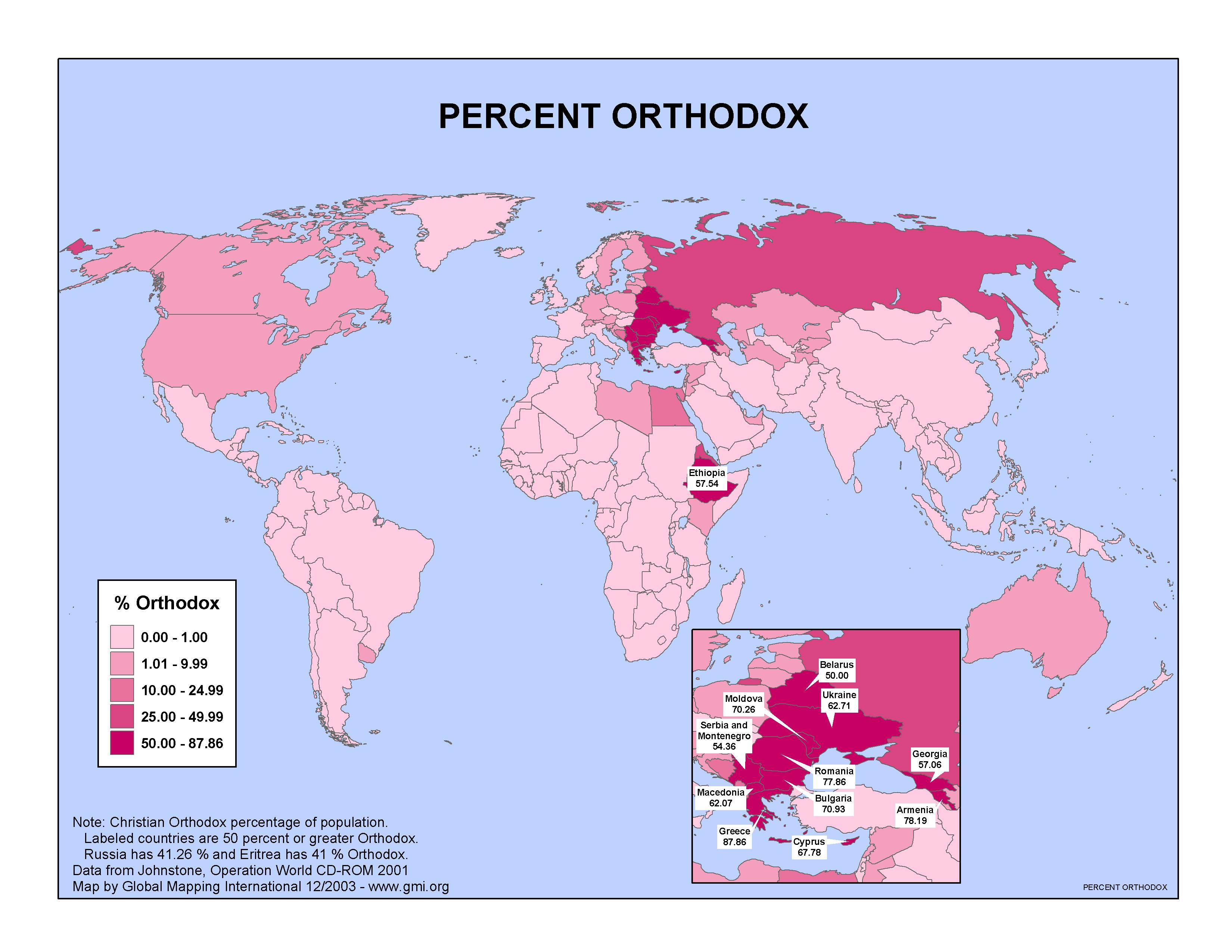 |
·Type: Maps ·Map Date: 2003 ·Data Source: Operation World CD 2001 ·Producer: GMI ·Collection: Projects 2003 ·Size: 8½ by 11 inches, landscape ·Categories: Type :: Maps Continent/Region :: World Topic :: Statistical Partners :: Global Mapping International Collection :: GMI Map Collections :: Projects 2003 Topic :: Religions, General :: Multiple/Other |
... more info
Max: 1
|
|
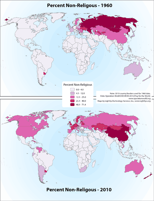 |
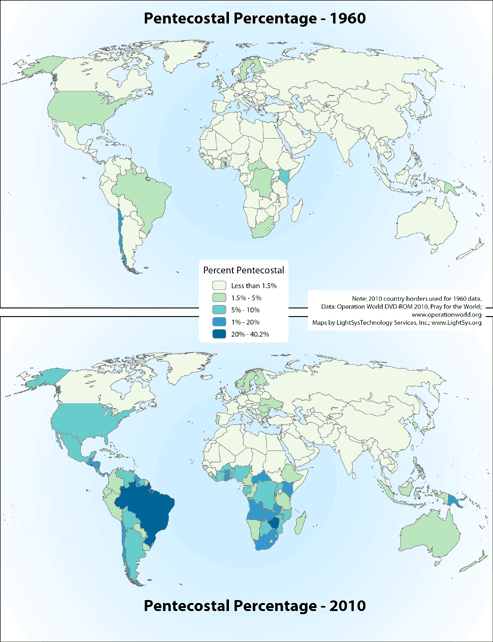
· Type: Maps · Map Date: 2019 · Data Source: Operation World 2010 DVD-ROM and Pray for the World. · Partners: Operation World/GMI, LightSys Technology Services · Collection: Projects 2019 · Size: 8½ x 11 inches, portrait · Categories: Type :: Maps Continent/Region :: World Topic :: Statistical Topic :: Religions, General :: Multiple/Other |
... more info
|
|
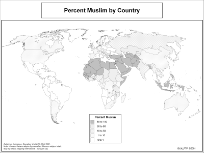 |
·Type: Maps ·Description: Percentage of Muslims in Countries Worldwide ·Map Date: 2002 ·Producer: Global Mapping International ·Collection: The World of Islam (WV 2002) ·Size: 8½ x 11 Inches, landscape ·Categories: Type :: Maps Collection :: GMI Map Collections :: The World of Islam (WV 2002) Continent/Region :: World Topic :: Statistical Partners :: Global Mapping International Topic :: Religions, General :: Islam |
... more info
Max: 1
|
|
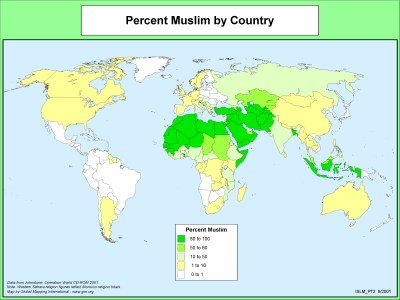 |
·Type: Maps ·Description: Percentage of Muslims in Countries Worldwide ·Map Date: 2000 ·Producer: Global Mapping International ·Collection: The World of Islam (WV 2002) ·Size: 8½ x 11 Inches, landscape ·Categories: Type :: Maps Collection :: GMI Map Collections :: The World of Islam (WV 2002) Continent/Region :: World Topic :: Statistical Partners :: Global Mapping International Topic :: Religions, General :: Islam |
... more info
Max: 1
|
|
 |
· Type: Maps · Map Date: 2019 · Data Source: Operation World 2010 DVD-ROM and Pray for the World. · Partners: Operation World/GMI, LightSys Technology Services · Collection: Projects 2019 · Size: 8½ x 11 inches, landscape · Categories: Type :: Maps Continent/Region :: World Topic :: Statistical Topic :: Religions, General :: Islam |
... more info
|
|