| Product Image |
Resource Name- |
Price |
Manufacturer |
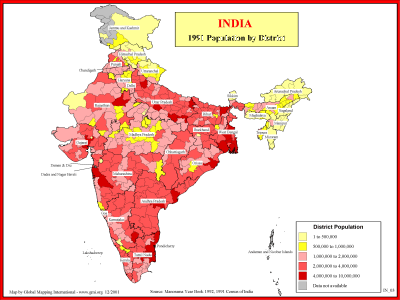 |
·Type: Maps ·Description: 1991 Population by district in India ·Map Date: 2001 ·Producer: Global Mapping International ·Collection: Reaching India (WorldVue 2002) ·Size: 8½ x 11 Inches, landscape ·Categories: Type :: Maps Collection :: GMI Map Collections :: Reaching India (WorldVue 2002) Continent/Region :: Asia Topic :: Statistical Topic :: Demography Country :: India Partners :: Global Mapping International |
... more info
Max: 1
|
|
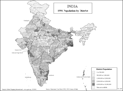 |
·Type: Maps ·Description: 1991 Population by district in India ·Map Date: 2002 ·Producer: Global Mapping International ·Collection: Reaching India (WorldVue 2002) ·Size: 8½ x 11 Inches, landscape ·Categories: Type :: Maps Collection :: GMI Map Collections :: Reaching India (WorldVue 2002) Continent/Region :: Asia Topic :: Statistical Topic :: Demography Country :: India Partners :: Global Mapping International |
... more info
Max: 1
|
|
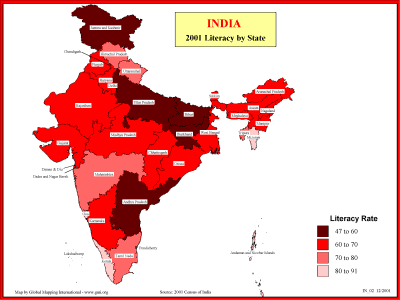 |
·Type: Maps ·Description: Statewide Literacy in 2001 ·Map Date: 2001 ·Producer: Global Mapping International ·Collection: Reaching India (WorldVue 2002) ·Size: 8½ x 11 Inches, landscape ·Categories: Type :: Maps Collection :: GMI Map Collections :: Reaching India (WorldVue 2002) Continent/Region :: Asia Topic :: Statistical Topic :: Social Country :: India Partners :: Global Mapping International |
... more info
Max: 1
|
|
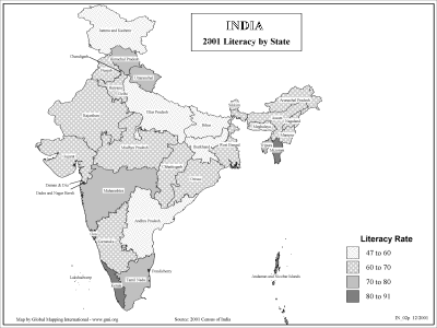 |
·Type: Maps ·Description: Statewide Literacy in 2001 ·Map Date: 2002 ·Producer: Global Mapping International ·Collection: Reaching India (WorldVue 2002) ·Size: 8½ x 11 Inches, landscape ·Categories: Type :: Maps Collection :: GMI Map Collections :: Reaching India (WorldVue 2002) Continent/Region :: Asia Topic :: Statistical Topic :: Social Country :: India Partners :: Global Mapping International |
... more info
Max: 1
|
|
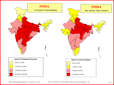 |
·Type: Maps ·Description: India's need for Church Planting Workers ·Map Date: 2001 ·Producer: Global Mapping International ·Collection: Reaching India (WorldVue 2002) ·Size: 8½ x 11 Inches, landscape ·Categories: Type :: Maps Collection :: GMI Map Collections :: Reaching India (WorldVue 2002) Continent/Region :: Asia Topic :: Statistical Topic :: Strategy Country :: India Partners :: Global Mapping International |
... more info
Max: 1
|
|
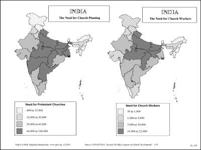 |
·Type: Maps ·Description: India's need for Church Planting Workers ·Map Date: 2002 ·Producer: Global Mapping International ·Collection: Reaching India (WorldVue 2002) ·Size: 8½ x 11 Inches, landscape ·Categories: Type :: Maps Collection :: GMI Map Collections :: Reaching India (WorldVue 2002) Continent/Region :: Asia Topic :: Statistical Topic :: Strategy Country :: India Partners :: Global Mapping International |
... more info
Max: 1
|
|
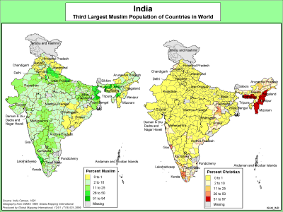 |
·Type: Maps ·Description: India's Muslim Population ·Map Date: 2000 ·Producer: Global Mapping International ·Collection: The World of Islam (WV 2002) ·Size: 8½ x 11 Inches, landscape ·Categories: Type :: Maps Collection :: GMI Map Collections :: The World of Islam (WV 2002) Continent/Region :: Asia Topic :: Statistical Country :: India Partners :: Global Mapping International Topic :: Religions, General :: Multiple/Other |
... more info
Max: 1
|
|
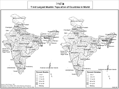 |
·Type: Maps ·Description: India's Muslim Population ·Map Date: 2002 ·Producer: Global Mapping International ·Collection: The World of Islam (WV 2002) ·Size: 8½ x 11 Inches, landscape ·Categories: Type :: Maps Collection :: GMI Map Collections :: The World of Islam (WV 2002) Continent/Region :: Asia Topic :: Statistical Country :: India Partners :: Global Mapping International Topic :: Religions, General :: Multiple/Other |
... more info
Max: 1
|
|
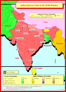 |
·Type: Maps ·Description: Gateway Cities in India to the 10/40 Window ·Map Date: 2001 ·Producer: Global Mapping International ·Collection: Reaching India (WorldVue 2002) ·Size: 8½ x 11 Inches, portrait ·Note: Windows Metafile and Metafile in Word forms of this map require the GMISym.ttf font ·Categories: Type :: Maps Collection :: GMI Map Collections :: Reaching India (WorldVue 2002) Continent/Region :: Asia Topic :: Statistical... |
... more info
Max: 1
|
|
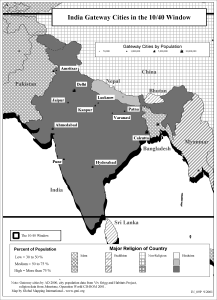 |
·Type: Maps ·Description: Gateway Cities in India to the 10/40 Window ·Map Date: 2002 ·Producer: Global Mapping International ·Collection: Reaching India (WorldVue 2002) ·Size: 8½ x 11 Inches, portrait ·Note: Windows Metafile and Metafile in Word forms of this map require the GMISym.ttf font ·Categories: Type :: Maps Collection :: GMI Map Collections :: Reaching India (WorldVue 2002) Continent/Region :: Asia Topic :: Statistical... |
... more info
Max: 1
|
|
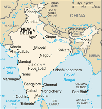 |
·Type: Maps ·Description: India (Factbook) ·Map Date: 2007 ·Producer: US Government ·Collection: World Factbook country maps ·Size: 634x323 px, landscape ·Categories: Type :: Maps Continent/Region :: Asia Country :: India Collection :: World Factbook country maps Partners :: U.S. Government |
... more info
Max: 1
|
|
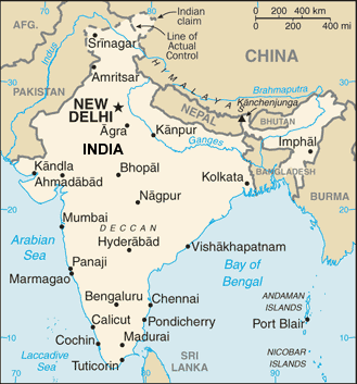 |
·Type: Maps ·Description: India (World Factbook, modified to add country name) ·Map Date: 2007 ·Producer: US Government modified by Joshua Project ·Collection: World Factbook country maps ·Size: 634x323 px, landscape ·Categories: Type :: Maps Continent/Region :: Asia Country :: India Collection :: World Factbook country maps Partners :: U.S. Government |
... more info
Max: 1
|
|
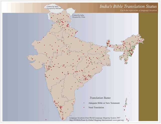 |
·Type: Maps ·Map Date: 2006 ·Data Source: World Language Mapping System 2006 ·Producer: Global Mapping International ·Collection: Reaching India (GMMS 2007) ·Size: 8½ x 11 inches, landscape ·Categories: Type :: Maps Continent/Region :: Asia Topic :: Statistical Country :: India Collection :: GMI Map Collections :: Reaching India (GMMS 2007) Partners :: Global Mapping International Topic :: Language and Translation |
... more info
Max: 1
|
|
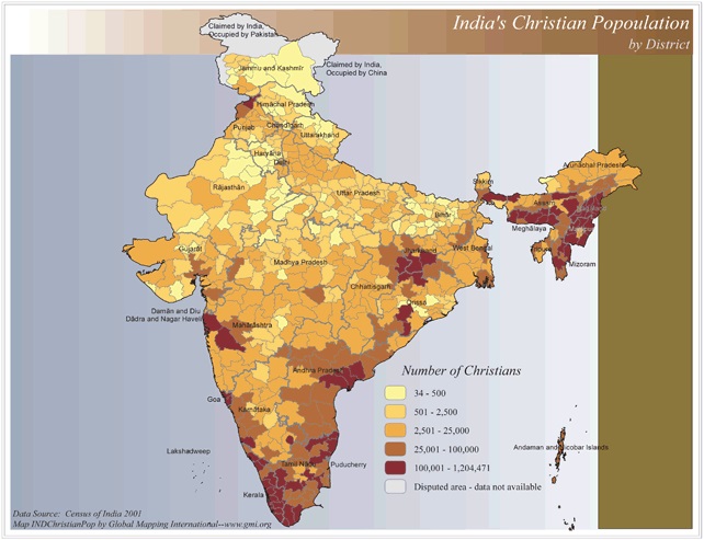 |
·Type: Maps ·Map Date: 2006 ·Data Source: Census of India 2001 ·Producer: Global Mapping International ·Collection: Reaching India (GMMS 2007) ·Size: 8½ x 11 inches, landscape ·Categories: Type :: Maps Continent/Region :: Asia Topic :: Statistical Country :: India Collection :: GMI Map Collections :: Reaching India (GMMS 2007) Partners :: Global Mapping International Topic :: Religions, Christianity :: Adherents, Churches, and Denoms |
... more info
Max: 1
|
|
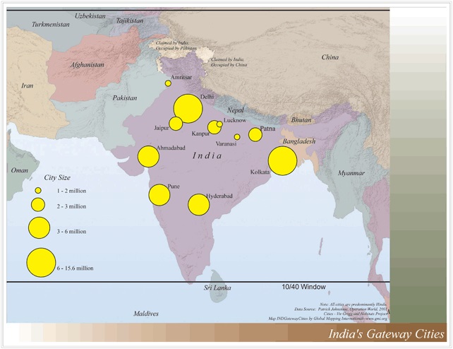 |
·Type: Maps ·Map Date: 2006 ·Data Source: Operation World 2001 Cities - Viv Grigg and Habitats Project ·Producer: Global Mapping International ·Collection: Reaching India (GMMS 2007) ·Size: 8½ x 11 inches, landscape ·Categories: Type :: Maps Continent/Region :: Asia Topic :: Statistical Topic :: Strategy Topic :: Concepts Topic :: Demography Country :: India Collection :: GMI Map Collections :: Reaching India (GMMS 2007) Partners ::... |
... more info
Max: 1
|
|
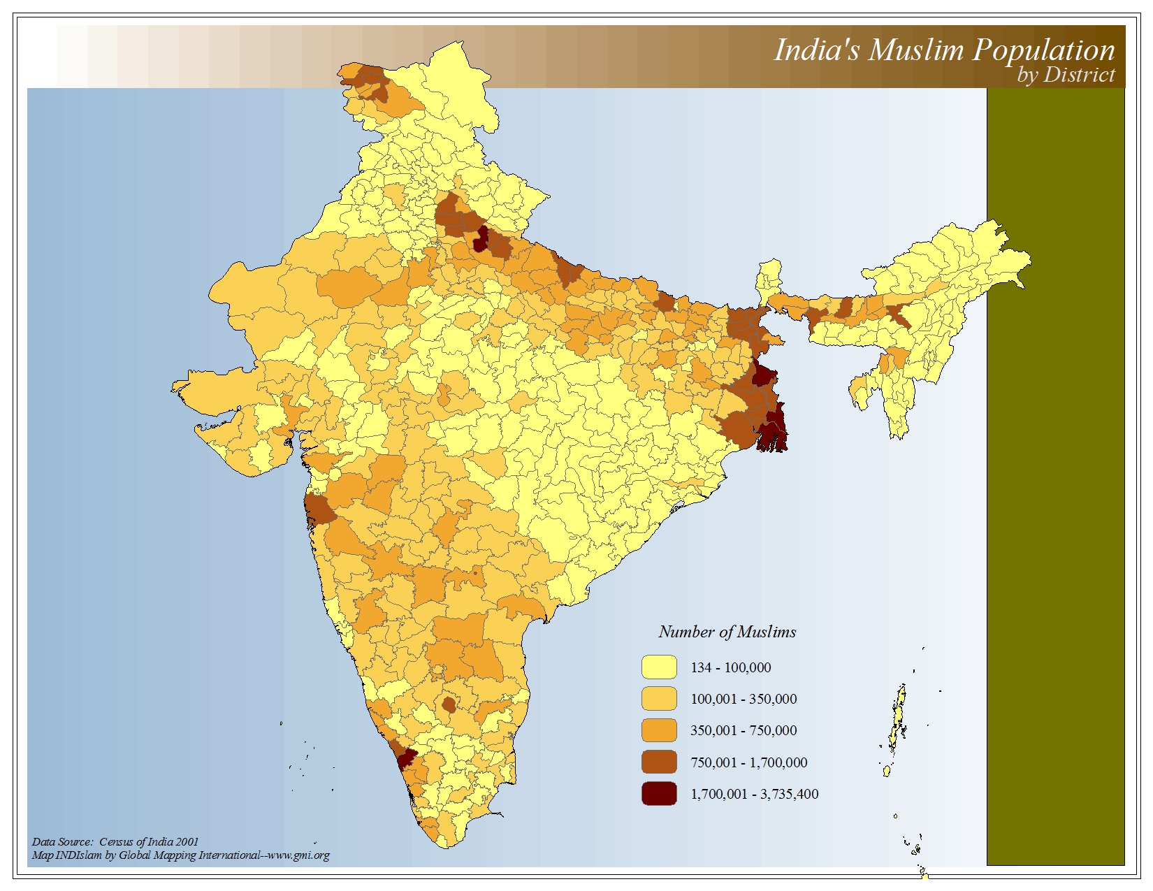 |
·Type: Maps ·Map Date: 2006 ·Data Source: Census of India 2001 ·Producer: Global Mapping International ·Collection: The World of Islam (GMMS 2007) ·Size: 8½ x 11 inches, landscape ·Categories: Type :: Maps Continent/Region :: Asia Topic :: Statistical Country :: India Collection :: GMI Map Collections :: The World of Islam (GMMS 2007) Partners :: Global Mapping International Topic :: Religions, General :: Islam |
... more info
Max: 1
|
|
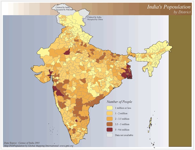 |
·Type: Maps ·Map Date: 2006 ·Data Source: Census of India 2001 ·Producer: Global Mapping International ·Collection: Reaching India (GMMS 2007) ·Size: 8½ x 11 inches, landscape ·Categories: Type :: Maps Continent/Region :: Asia Topic :: Statistical Topic :: Demography Country :: India Collection :: GMI Map Collections :: Reaching India (GMMS 2007) Partners :: Global Mapping International |
... more info
Max: 1
|
|
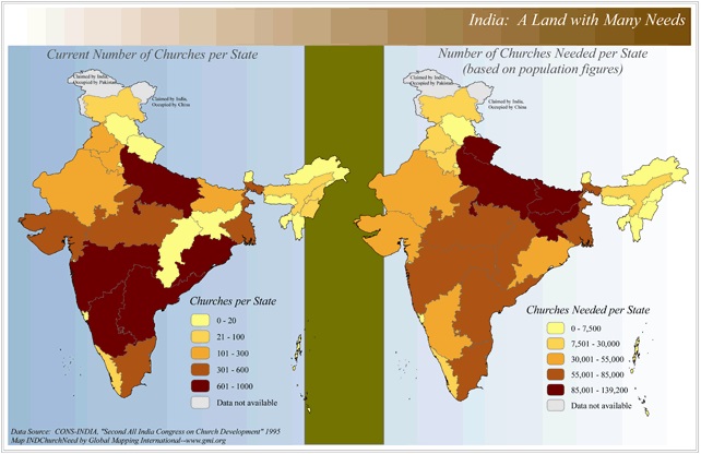 |
·Type: Maps ·Map Date: 2006 ·Data Source: CONS-INDIA, "Second All India Congress on Church Development" 1995 ·Producer: Global Mapping International ·Collection: Reaching India (GMMS 2007) ·Size: 8½ x 13 inches, landscape ·Categories: Type :: Maps Continent/Region :: Asia Topic :: Statistical Topic :: Strategy Country :: India Collection :: GMI Map Collections :: Reaching India (GMMS 2007) Partners :: Global Mapping International Topic ::... |
... more info
Max: 1
|
|
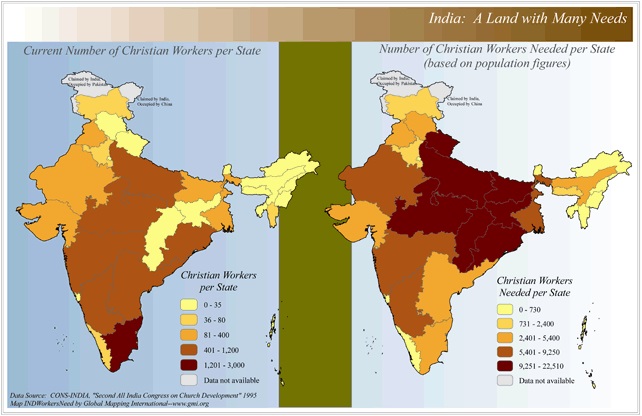 |
·Type: Maps ·Map Date: 2006 ·Data Source: CONS-INDIA, "Second All India Congress on Church Development" 1995 ·Producer: Global Mapping International ·Collection: Reaching India (GMMS 2007) ·Size: 8½ x 13 inches, landscape ·Categories: Type :: Maps Continent/Region :: Asia Topic :: Statistical Topic :: Strategy Country :: India Collection :: GMI Map Collections :: Reaching India (GMMS 2007) Partners :: Global Mapping International |
... more info
Max: 1
|
|
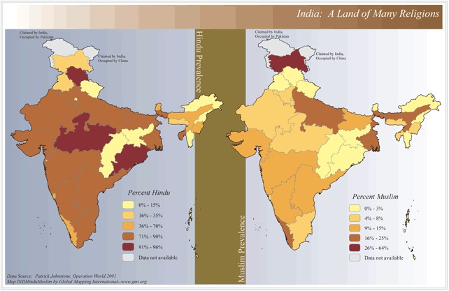 |
·Type: Maps ·Map Date: 2006 ·Data Source: Patrick Johnstone, Operation World 2001 ·Producer: Global Mapping International ·Collection: Reaching India (GMMS 2007) ·Size: 8½ x 13 inches, landscape ·Categories: Type :: Maps Continent/Region :: Asia Topic :: Statistical Country :: India Collection :: GMI Map Collections :: Reaching India (GMMS 2007) Partners :: Global Mapping International Topic :: Religions, General :: Multiple/Other |
... more info
Max: 1
|
|
 |
widespread folk Islam and rising fundamentalism With more than 25,000 islands, the Indo-Malaysia region has a population of about 420 million people. The equator runs through the center of the region, and tropical rainforest climates are typical. Many of the islands are mountainous, with both dormant and active volcanoes. For more information go to Indo-Malaysia on the Prayercast website. The above link opens in a new tab. |

Max: 1
|
|
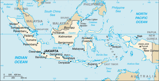 |
·Type: Maps ·Description: Indonesia (Factbook) ·Map Date: 2007 ·Producer: US Government ·Collection: World Factbook country maps ·Size: 635x325 px, landscape ·Categories: Type :: Maps Continent/Region :: Asia Country :: Indonesia Collection :: World Factbook country maps Partners :: U.S. Government |
... more info
Max: 1
|
|
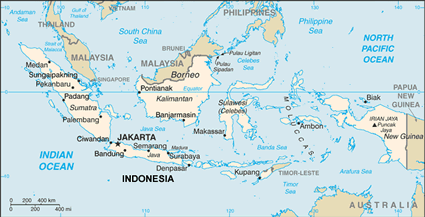 |
·Type: Maps ·Description: Indonesia (World Factbook, modified to add country name) ·Map Date: 2007 ·Producer: US Government modified by Joshua Project ·Collection: World Factbook country maps ·Size: 635x325 px, landscape ·Categories: Type :: Maps Continent/Region :: Asia Country :: Indonesia Collection :: World Factbook country maps Partners :: U.S. Government |
... more info
Max: 1
|
|
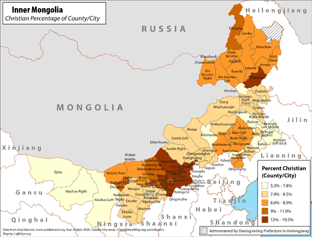 |
· Type: Maps · Map Date: 2019 · Data Source: Asia Harvest; county/city areas © OpenStreetMap contributors, http://www.openstreetmap.org/copyright. Data available under the Open Database License · Partners: LightSys Technology Services · Collection: Projects 2019 · Size: 8½ x 11 inches, landscape · Categories: Type :: Maps Continent/Region :: Asia Country :: China Topic :: Statistical Topic :: Religions,... |
... more info
|
|
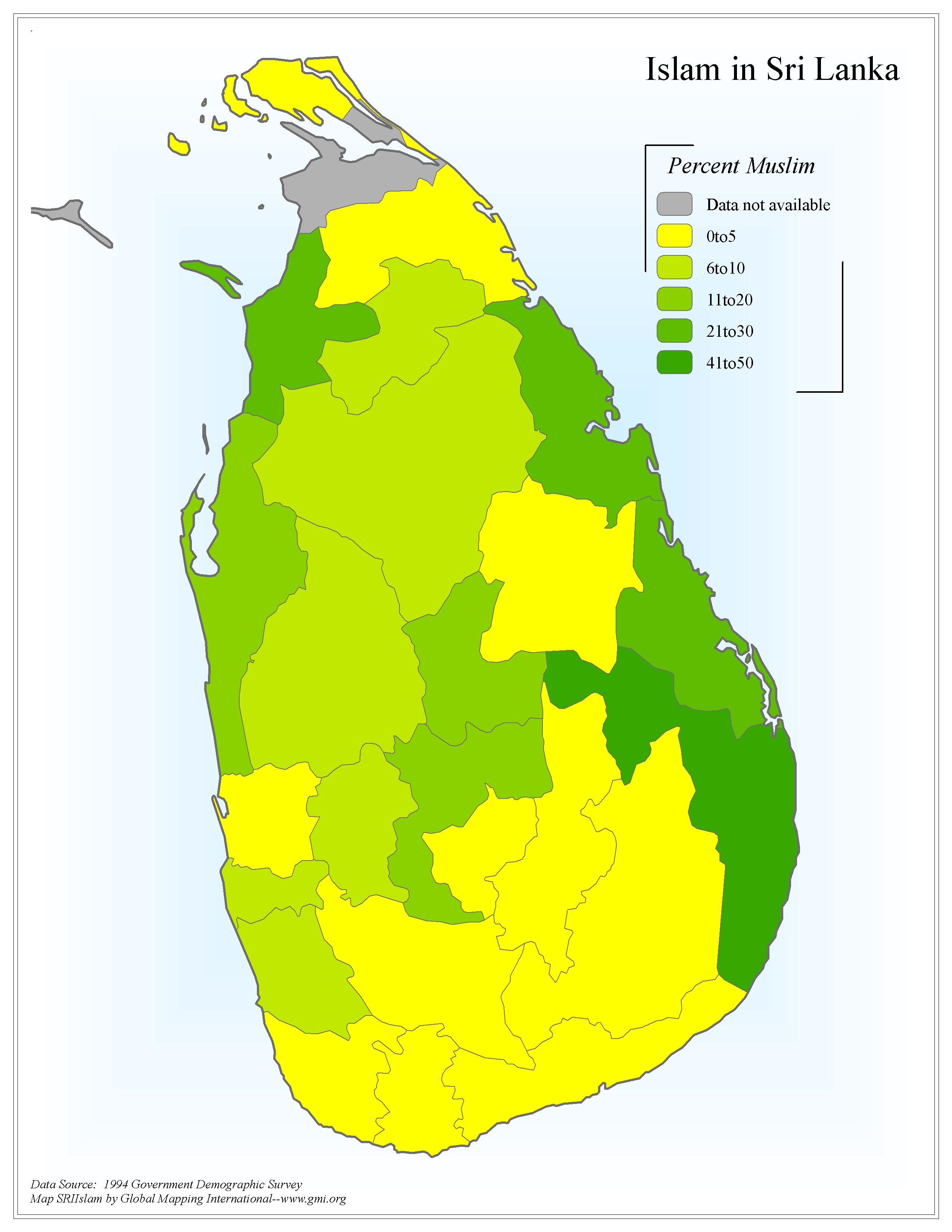 |
·Type: Maps ·Map Date: 2006 ·Data Source: 1994 Government Demographic Survey ·Producer: Global Mapping International ·Collection: Sri Lanka (GMMS 2007) ·Size: 8½ x 11 inches, portrait ·Categories: Type :: Maps Country :: Sri Lanka Continent/Region :: Asia Topic :: Statistical Collection :: GMI Map Collections :: Sri Lanka (GMMS 2007) Partners :: Global Mapping International Topic :: Religions, General :: Islam |
... more info
Max: 1
|
|