| Product Image |
Resource Name |
Price |
Manufacturer+ |
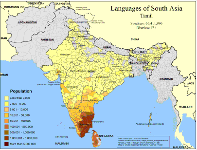 |
·Type: Maps ·Map Date: February 2008 ·Data Source: Census Information, UNESCO (1987) through UNEP/GRID-Sioux Falls ·Producer: Global Mapping International and The Joshua Project ·Size: 11.7 by 8.27 inches, landscape ·Categories: Type :: Maps Country :: Sri Lanka Continent/Region :: Asia Topic :: Demography Country :: India Partners :: Global Mapping International Topic :: Language and Translation Partners :: Joshua Project |
... more info
Max: 1
|
|
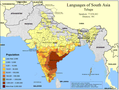 |
·Type: Maps ·Map Date: February 2008 ·Data Source: Census Information, UNESCO (1987) through UNEP/GRID-Sioux Falls ·Producer: Global Mapping International and The Joshua Project ·Size: 11.7 by 8.27 inches, landscape ·Categories: Type :: Maps Continent/Region :: Asia Topic :: Demography Country :: India Country :: Bangladesh Partners :: Global Mapping International Topic :: Language and Translation Partners :: Joshua Project |
... more info
Max: 1
|
|
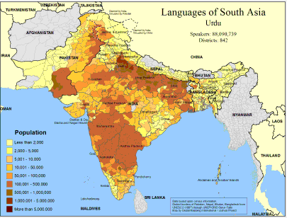 |
·Type: Maps ·Map Date: February 2008 ·Data Source: Census Information, UNESCO (1987) through UNEP/GRID-Sioux Falls ·Producer: Global Mapping International and The Joshua Project ·Size: 11.7 by 8.27 inches, landscape ·Categories: Type :: Maps Continent/Region :: Asia Topic :: Demography Country :: Nepal Country :: India Country :: Bangladesh Country :: Pakistan Partners :: Global Mapping International Topic :: Language and Translation Partners ::... |
... more info
Max: 1
|
|
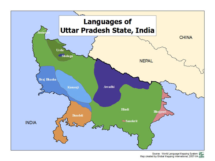 |
·Type: Maps ·Map Date: 2007 ·Data Source: World Language Mapping Systems ·Producer: GMI ·Collection: Projects 2007 ·Size: 7½ by 10 inches, landscape ·Categories: Type :: Maps Country :: India Partners :: Global Mapping International Collection :: GMI Map Collections :: Projects 2007 Topic :: Language and Translation |
... more info
Max: 1
|
|
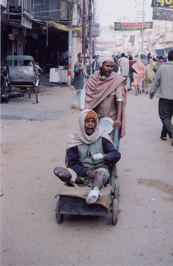 |
·Type: Images ·Data Source: YWAM/John Fries ·Collection: YWAM-John Fries ·Categories: Topic :: Peoples, multiple or unknown Country :: India Collection :: YWAM-John Fries Partners :: YWAM-John Fries Topic :: Images: Country :: India Type :: Images :: by provider :: YWAM-John Fries Type :: Images :: by country :: India |
... more info
Max: 1
|
|
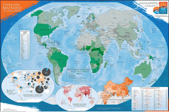 |
Disponible en francés, inglés, portugués y ruso. Este mapa en español de colores (60.96 cm por 91.44 cm) destaca información y estadística encontrada en Operación Muro Mundo y en Ora por el Mundo . El mapa principal incluye el porcentaje de Cristianos en los 30 países más grandes, el número de los pueblos menos-alcanzados en cada país, y el porcentaje de Cristianos por provincia de la China y de la India. ·Type: Maps ·Map Date: 2019 ·Categories: Collection ::... |
... more info
|
|
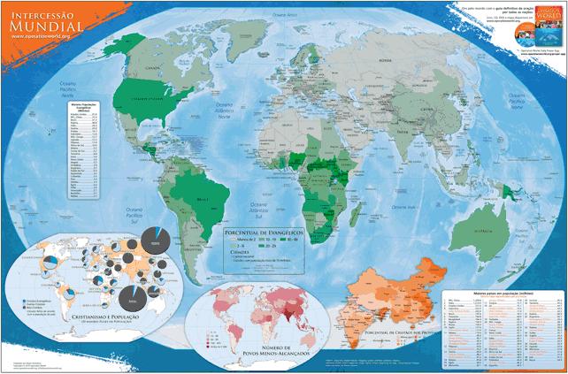 |
Disponível em inglês, francês, russo e et espanhol. Este mapa do mundo em cores do tamanho de 60,96 cm x 91,44 cm destaca as informações dos livros Intercessão Mundial (7ª edição - 2010) e Ore pelas Nações . O mapa principal mostra a porcentagem de evangélicos por país. Os mapas inseridos também mostram a porcentagem de cristãos nos 30 maiores países, o número de povos menos alcançados por país e a porcentagem de cristãos na China e na Índia por província. ·Type:... |
... more info
|
|
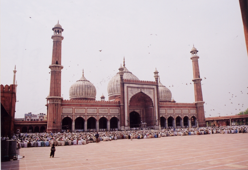 |
·Type: Images ·Data Source: YWAM/John Fries ·Collection: YWAM-John Fries ·Categories: Country :: India Collection :: YWAM-John Fries Partners :: YWAM-John Fries Topic :: Images: Country :: India Type :: Images :: by provider :: YWAM-John Fries Type :: Images :: by country :: India Topic :: Geography :: Architecture |
... more info
Max: 1
|
|
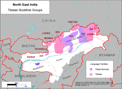 |
·Type: Maps ·Description: Major Tibetan Buddhist Groups in North East India ·Map Date: 2001 ·Producer: Global Mapping International ·Collection: Himalayan Buddhist Ppl (WV 2002) ·Size: 8½ x 11 Inches, landscape ·Note: Windows Metafile and Metafile in Word forms of this map require the GMISym.ttf font ·Categories: Type :: Maps Collection :: GMI Map Collections :: Himalayan Buddhist Ppl (WV 2002) Continent/Region :: Asia Topic ::... |
... more info
Max: 1
|
|
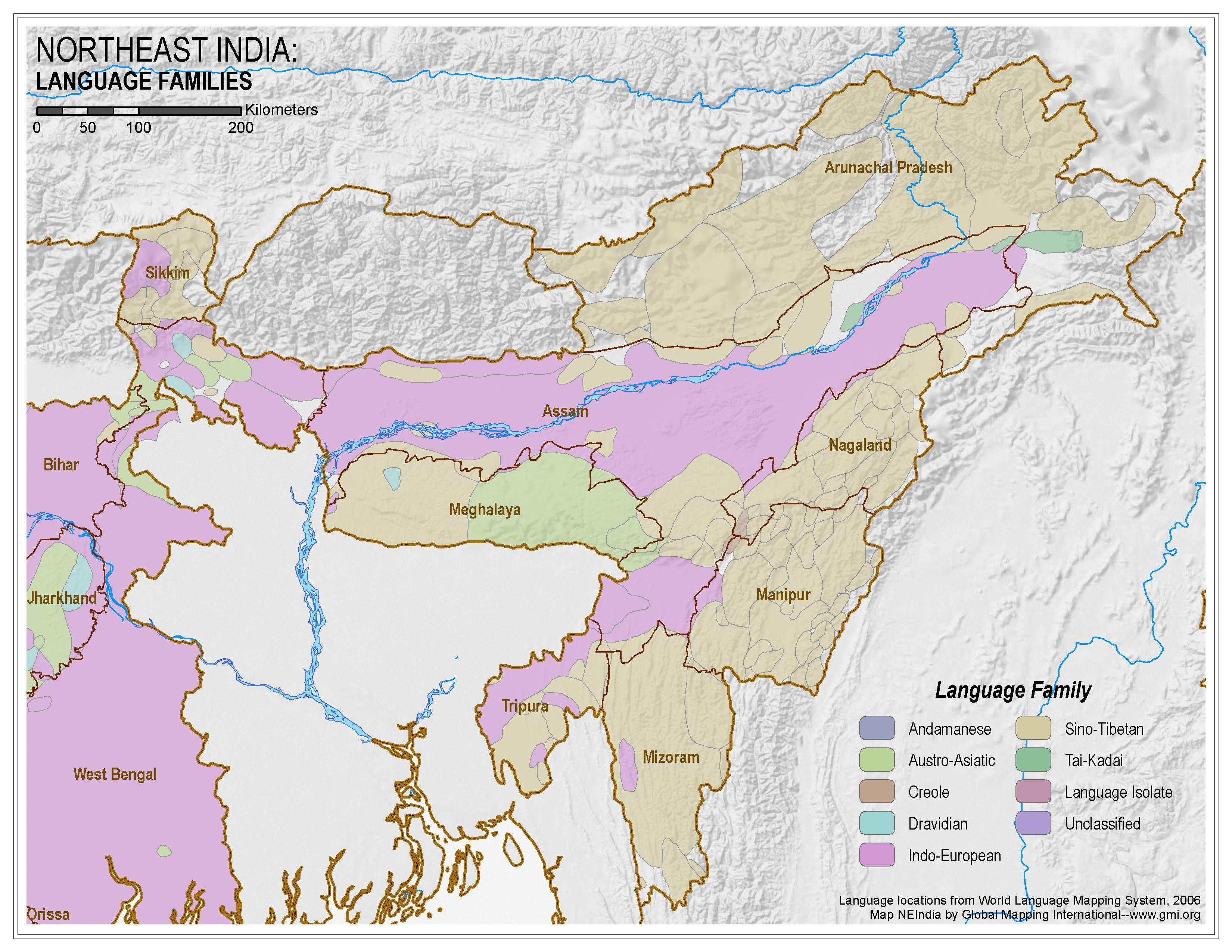 |
·Type: Maps ·Map Date: 2006 ·Data Source: World Language Mapping System, 2006 ·Producer: Global Mapping International ·Collection: Himalayan Budd Ppl (GMMS 2007) ·Size: 8½ x 11 inches, landscape ·Categories: Type :: Maps Continent/Region :: Asia Topic :: Peoples, multiple or unknown Country :: India Collection :: GMI Map Collections :: Himalayan Budd Ppl (GMMS 2007) Partners :: Global Mapping International |
... more info
Max: 1
|
|
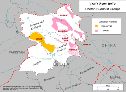 |
·Type: Maps ·Description: Tibetan Buddhist Groups in North West India ·Map Date: 1999 ·Producer: Global Mapping International ·Collection: Himalayan Buddhist Ppl (WV 2002) ·Size: 8½ x 11 Inches, landscape ·Note: Windows Metafile and Metafile in Word forms of this map require the GMISym.ttf font ·Categories: Type :: Maps Collection :: GMI Map Collections :: Himalayan Buddhist Ppl (WV 2002) Continent/Region :: Asia Topic :: Peoples,... |
... more info
Max: 1
|
|
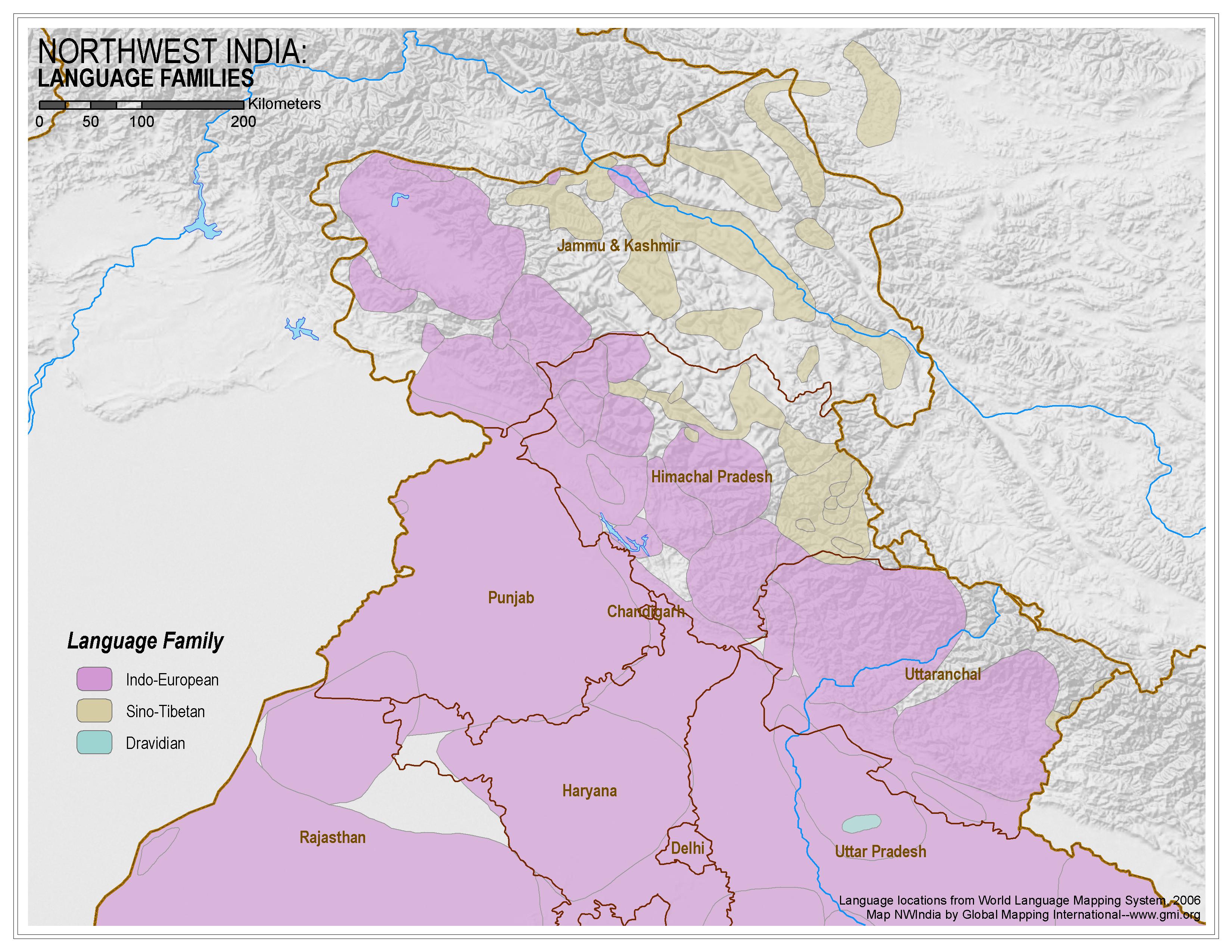 |
·Type: Maps ·Map Date: 2006 ·Data Source: World Language Mapping System, 2006 ·Producer: Global Mapping International ·Collection: Himalayan Budd Ppl (GMMS 2007) ·Size: 8½ x 11 inches, landscape ·Categories: Type :: Maps Continent/Region :: Asia Topic :: Peoples, multiple or unknown Country :: India Collection :: GMI Map Collections :: Himalayan Budd Ppl (GMMS 2007) Partners :: Global Mapping International |
... more info
Max: 1
|
|
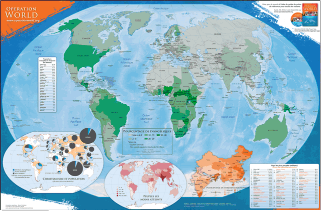 |
This colored Spanish map (60.96 cm by 91.44 cm) highlights information and statistics found in Operation Muro Mundo and in Pray for the World. The main map includes the percentage of Christians in the 30 largest countries, the number of the least-reached peoples in each country, and the percentage of Christians by province of China and India. For more information go to Operation World Wall Map on the Operation World website. The above link opens in a new tab. |
... more info
|
|
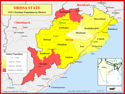 |
·Type: Maps ·Description: Christian Population of Orissa state in 1991 ·Map Date: 1999 ·Producer: Global Mapping International ·Collection: Reaching India (WorldVue 2002) ·Size: 8½ x 11 Inches, landscape ·Note: Windows Metafile and Metafile in Word forms of this map require the GMISym.ttf font ·Categories: Type :: Maps Collection :: GMI Map Collections :: Reaching India (WorldVue 2002) Continent/Region :: Asia Topic :: Statistical... |
... more info
Max: 1
|
|
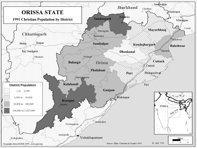 |
·Type: Maps ·Description: Christian Population of Orissa state in 1991 ·Map Date: 2002 ·Producer: Global Mapping International ·Collection: Reaching India (WorldVue 2002) ·Size: 8½ x 11 Inches, landscape ·Note: Windows Metafile and Metafile in Word forms of this map require the GMISym.ttf font ·Categories: Type :: Maps Collection :: GMI Map Collections :: Reaching India (WorldVue 2002) Continent/Region :: Asia Topic :: Statistical... |
... more info
Max: 1
|
|
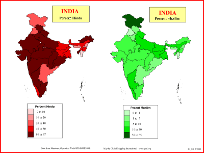 |
·Type: Maps ·Description: Percent Hindu and Muslim in India ·Map Date: 2001 ·Producer: Global Mapping International ·Collection: Reaching India (WorldVue 2002) ·Size: 8½ x 11 Inches, landscape ·Categories: Type :: Maps Collection :: GMI Map Collections :: Reaching India (WorldVue 2002) Continent/Region :: Asia Topic :: Statistical Country :: India Partners :: Global Mapping International Topic :: Religions, General :: Multiple/Other |
... more info
Max: 1
|
|
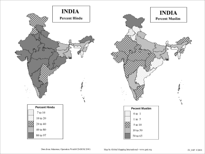 |
·Type: Maps ·Description: Percent Hindu and Muslim in India ·Map Date: 2002 ·Producer: Global Mapping International ·Collection: Reaching India (WorldVue 2002) ·Size: 8½ x 11 Inches, landscape ·Categories: Type :: Maps Collection :: GMI Map Collections :: Reaching India (WorldVue 2002) Continent/Region :: Asia Topic :: Statistical Country :: India Partners :: Global Mapping International Topic :: Religions, General :: Multiple/Other |
... more info
Max: 1
|
|
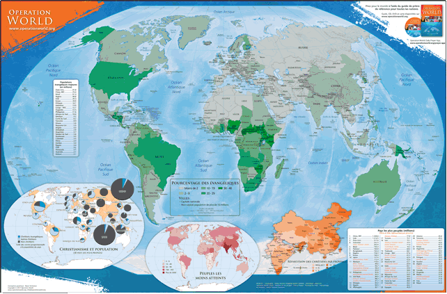 |
Disponible en anglais, portugais, russe et espagnol. Cette carte du monde en couleur de 36 po x 24 po (60.96 cm x 91.44 cm) correspond avec la 7e edition (2010) de Operation World et contient les informations et statistiques citées en Pray for the World . La carte principale donne le pourcentage des populations Évangéliques de chaque pays. Les cartes en médaillon donnent le pourcentage des Chrétiens des 30 plus grands pays du monde, le nombre de peuples... |
... more info
|
|
 |
Words that best describe the history of Northern India are invasion, conquest, and migration. “Rajput” originally referred to the various clans that ruled ancient South Asia. Once known as the ruling class, many Rajputs now struggle with identity issues related to class and nationality. In many communities, the Rajput are in desperate need of basic services such as clean water and homes. There are known believers among them, but no known movement to Christ.... |
... more info
|
|
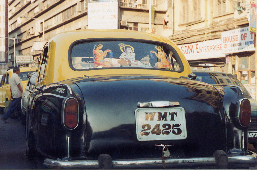 |
·Type: Images ·Data Source: YWAM/John Fries ·Collection: YWAM-John Fries ·Categories: Country :: India Collection :: YWAM-John Fries Partners :: YWAM-John Fries Topic :: Images: Country :: India Type :: Images :: by provider :: YWAM-John Fries Type :: Images :: by country :: India Topic :: Geography :: Landscape |
... more info
Max: 1
|
|
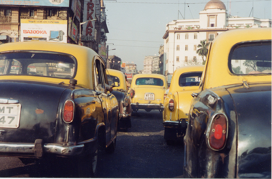 |
·Type: Images ·Data Source: YWAM/John Fries ·Collection: YWAM-John Fries ·Categories: Country :: India Collection :: YWAM-John Fries Partners :: YWAM-John Fries Topic :: Images: Country :: India Type :: Images :: by provider :: YWAM-John Fries Type :: Images :: by country :: India Topic :: Geography :: Landscape |
... more info
Max: 1
|
|
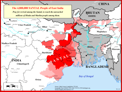 |
·Type: Maps ·Description: The Santal People in Eastern India ·Map Date: 1999 ·Producer: Global Mapping International ·Collection: Reaching India (WorldVue 2002) ·Size: 8½ x 11 Inches, landscape ·Note: Windows Metafile and Metafile in Word forms of this map require the GMISym.ttf font ·Categories: Type :: Maps Collection :: GMI Map Collections :: Reaching India (WorldVue 2002) Continent/Region :: Asia Topic :: Strategy Country ::... |
... more info
Max: 1
|
|
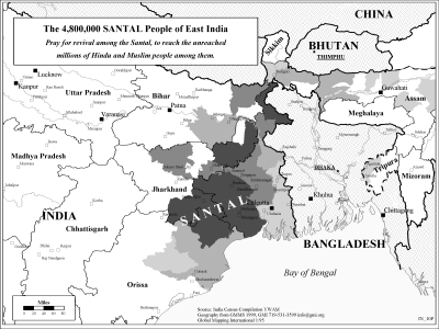 |
·Type: Maps ·Description: The Santal People in Eastern India ·Map Date: 2002 ·Producer: Global Mapping International ·Collection: Reaching India (WorldVue 2002) ·Size: 8½ x 11 Inches, landscape ·Note: Windows Metafile and Metafile in Word forms of this map require the GMISym.ttf font ·Categories: Type :: Maps Collection :: GMI Map Collections :: Reaching India (WorldVue 2002) Continent/Region :: Asia Topic :: Strategy Country ::... |
... more info
Max: 1
|
|
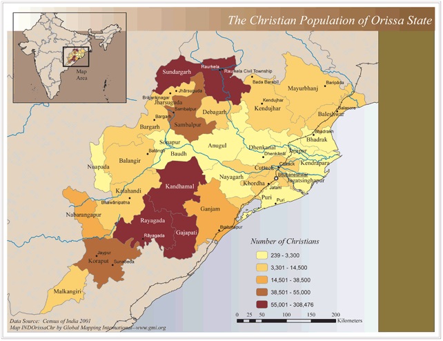 |
·Type: Maps ·Map Date: 2006 ·Data Source: Census of India 2001 ·Producer: Global Mapping International ·Collection: Reaching India (GMMS 2007) ·Size: 8½ x 11 inches, landscape ·Categories: Type :: Maps Continent/Region :: Asia Topic :: Statistical Country :: India Collection :: GMI Map Collections :: Reaching India (GMMS 2007) Partners :: Global Mapping International Topic :: Religions, Christianity :: Adherents, Churches, and Denoms |
... more info
Max: 1
|
|
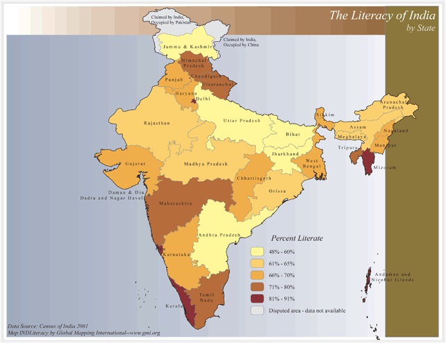 |
·Type: Maps ·Map Date: 2006 ·Data Source: Census of India 2001 ·Producer: Global Mapping International ·Collection: Reaching India (GMMS 2007) ·Size: 8½ x 11 inches, landscape ·Categories: Type :: Maps Continent/Region :: Asia Topic :: Statistical Topic :: Social Country :: India Collection :: GMI Map Collections :: Reaching India (GMMS 2007) Partners :: Global Mapping International |
... more info
Max: 1
|
|