| Product Image |
Resource Name- |
Price |
Manufacturer |
 |
Progress Scale: Unreached Population: 171,186,000 Area Square Miles: 55,598 Capital: Dhaka % Literacy: 74.00 % Islam: 90.42 % Professing Christian: 0.37 % Evangelical: 0.00 For more information go to Bangladesh on the Joshua Project website. The above link opens in a new tab. |
... more info
Max: 1
|
|
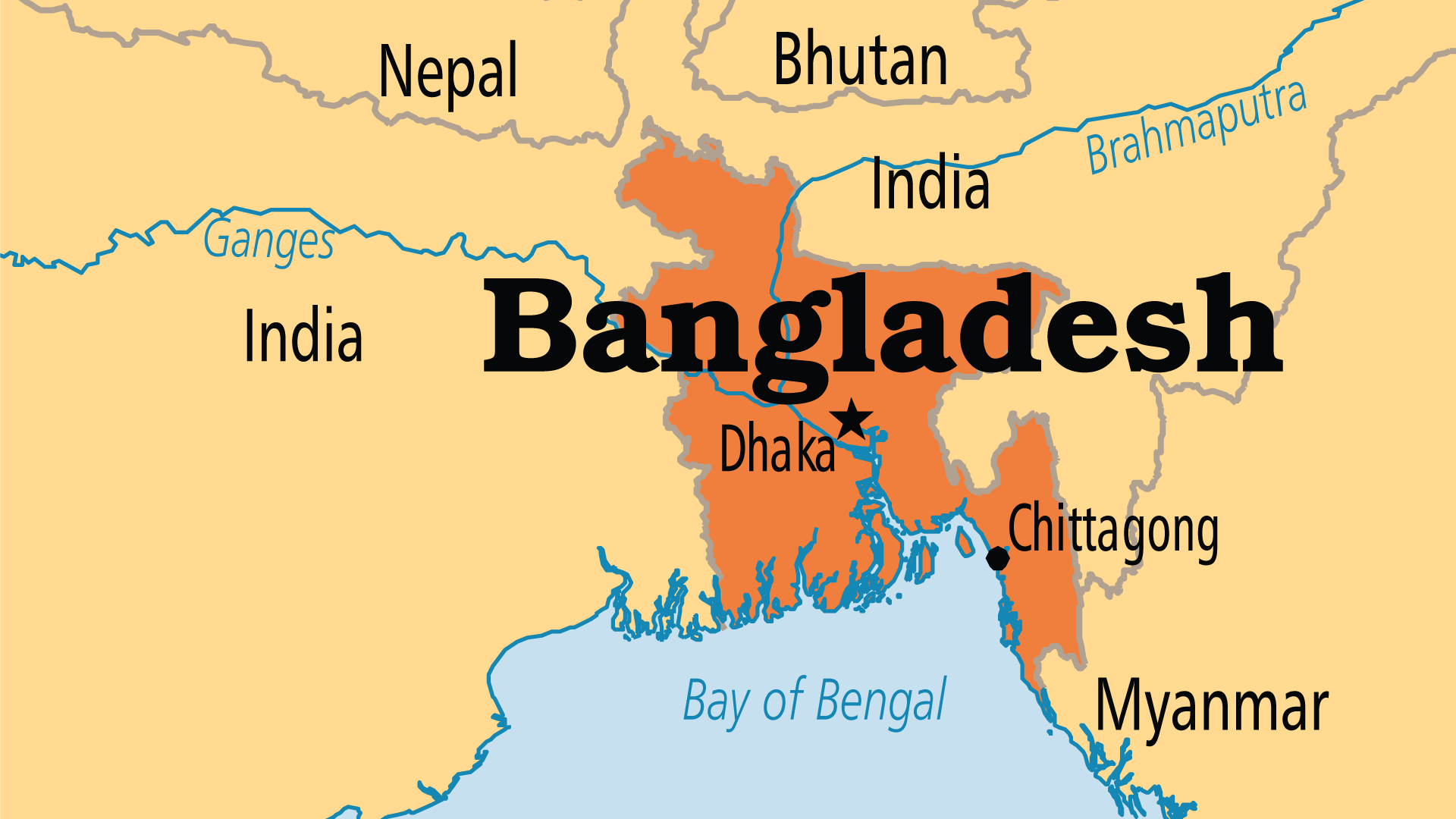 |
Largest Religion: Muslim Number People Groups: 326 Number Languages: 46 Official Language: Bengla; English also used For more information go to Bangladesh on the Operation World website. The above link opens in a new tab. |

Max: 1
|
|
 |
Government: Parliamentary Democracy Major People Groups: Bengali GDP Per Capita: $4,200 Literacy Rate: 72.80% Unreached: 89.90% For more information go to Bangladesh on the Prayercast website. The above link opens in a new tab. |

Max: 1
|
|
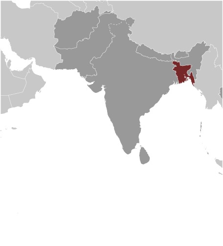 |
Area: 148,460 Population: 162,650,853 July 2020 est. Life Expectancy: 74.20 Net migration rate: -3.00 2020 est. GDP (real growth rate): 7.40 2017 est. Internet Users: 23,917,950 For more information go to Bangladesh on the World Factbook website. The above link opens in a new tab. |

Max: 1
|
|
 |
NOTE: The most recent year's information is shown below. Click on the year to see all years for this indicator. COMMUNICATION2018 156,989,177 Mobile cellular subscriptions2017 15 Individuals using the Internet (% of population)ECONOMY2014 17 Energy imports, net (% of energy use)2014 320 Electric power consumption (kWh per capita)2016 0.84 Pump price for diesel fuel (US$ per... |
... more info
|
|
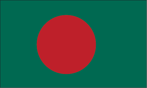 |
·Type: Images ·Collection: World Factbook country flags ·Small size: 90 x 54 px ·Large size: 503 x 302 px ·Categories: Collection :: World Factbook country flags Country :: Bangladesh Partners :: U.S. Government Topic :: Flags Topic :: Images: Country :: Bangladesh Type :: Images :: by country :: Bangladesh |
... more info
Max: 1
|
|
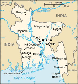 |
·Type: Maps ·Description: Bangladesh (Factbook) ·Map Date: 2007 ·Producer: US Government ·Collection: World Factbook country maps ·Size: 328x353 px, portrait ·Categories: Type :: Maps Continent/Region :: Asia Collection :: World Factbook country maps Country :: Bangladesh Partners :: U.S. Government |
... more info
Max: 1
|
|
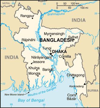 |
·Type: Maps ·Description: Bangladesh (World Factbook, modified to add country name) ·Map Date: 2007 ·Producer: US Government modified by Joshua Project ·Collection: World Factbook country maps ·Size: 328x353 px, portrait ·Categories: Type :: Maps Continent/Region :: Asia Collection :: World Factbook country maps Country :: Bangladesh Partners :: U.S. Government |
... more info
Max: 1
|
|
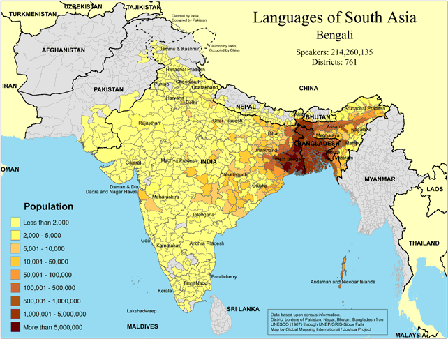 |
·Type: Maps ·Map Date: 2018 ·Data Source: Omid, based on census information ·Partners: OMID 2018 ·Size: 8.27 by 11.69 inches, landscape ·Categories: Type :: Maps Continent/Region :: Asia Country :: Bangladesh Country :: India Country :: Nepal Country :: Bhutan Partners :: OMID Collection :: Map Collections :: OMID 2018 Topic :: Language and Translation |
... more info
|
|
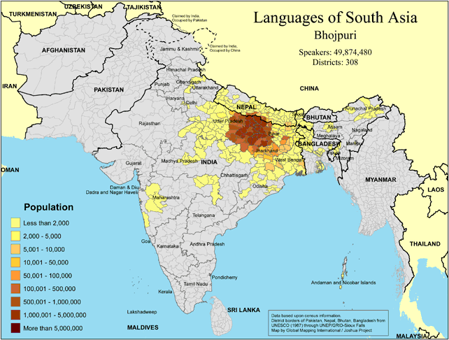 |
·Type: Maps ·Map Date: 2018 ·Data Source: Omid, based on census information ·Partners: OMID 2018 ·Size: 8.27 by 11.69 inches, landscape ·Categories: Type :: Maps Continent/Region :: Asia Country :: India Country :: Nepal Country :: Bangladesh Partners :: OMID Collection :: Map Collections :: OMID 2018 Topic :: Language and Translation |
... more info
|
|
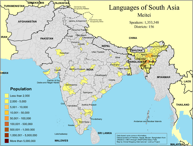 |
·Type: Maps ·Map Date: 2018 ·Data Source: Omid, based on census information ·Partners: OMID 2018 ·Size: 8.27 by 11.69 inches, landscape ·Categories: Type :: Maps Continent/Region :: Asia Country :: India Country :: Bangladesh Partners :: OMID Collection :: Map Collections :: OMID 2018 Topic :: Language and Translation |
... more info
|
|
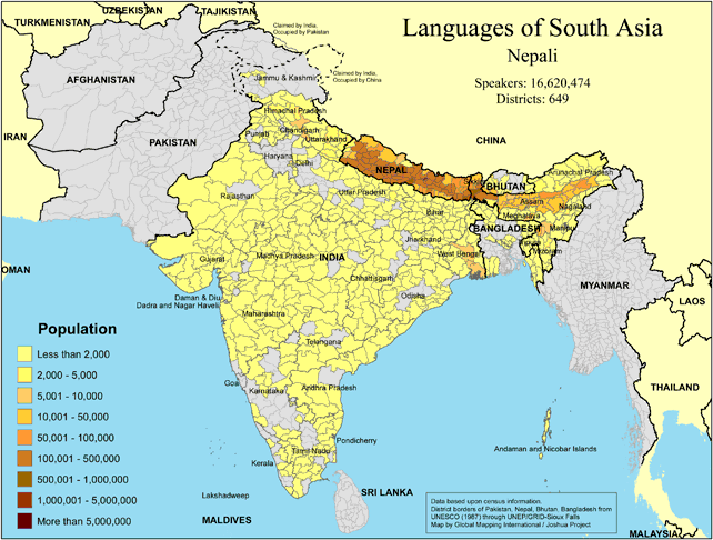 |
·Type: Maps ·Map Date: 2018 ·Data Source: Omid, based on census information ·Partners: OMID 2018 ·Size: 8.27 by 11.69 inches, landscape ·Categories: Type :: Maps Continent/Region :: Asia Country :: Nepal Country :: India Country :: Bhutan Country :: Bangladesh Partners :: OMID Collection :: Map Collections :: OMID 2018 Topic :: Language and Translation |
... more info
|
|
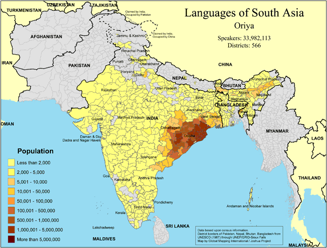 |
·Type: Maps ·Map Date: 2018 ·Data Source: Omid, based on census information ·Partners: OMID 2018 ·Size: 8.27 by 11.69 inches, landscape ·Categories: Type :: Maps Continent/Region :: Asia Country :: India Country :: Bangladesh Partners :: OMID Collection :: Map Collections :: OMID 2018 Topic :: Language and Translation |
... more info
|
|
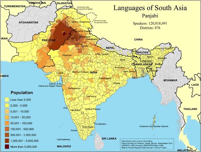 |
·Type: Maps ·Map Date: 2018 ·Data Source: Omid, based on census information ·Partners: OMID 2018 ·Size: 8.27 by 11.69 inches, landscape ·Categories: Type :: Maps Continent/Region :: Asia Country :: Pakistan Country :: India Country :: Bangladesh Partners :: OMID Collection :: Map Collections :: OMID 2018 Topic :: Language and Translation |
... more info
|
|
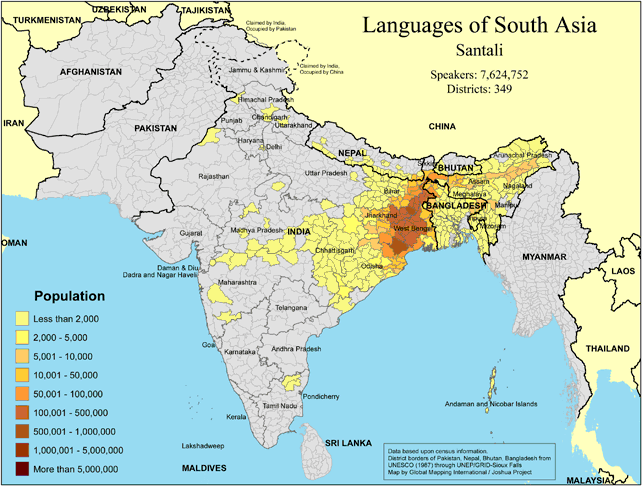 |
·Type: Maps ·Map Date: 2018 ·Data Source: Omid, based on census information ·Partners: OMID 2018 ·Size: 8.27 by 11.69 inches, landscape ·Categories: Type :: Maps Continent/Region :: Asia Country :: India Country :: Bangladesh Partners :: OMID Collection :: Map Collections :: OMID 2018 Topic :: Language and Translation |
... more info
|
|
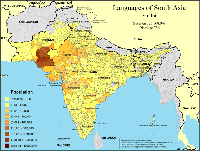 |
·Type: Maps ·Map Date: 2018 ·Data Source: Omid, based on census information ·Partners: OMID 2018 ·Size: 8.27 by 11.69 inches, landscape ·Categories: Type :: Maps Continent/Region :: Asia Country :: Pakistan Country :: India Country :: Bangladesh Partners :: OMID Collection :: Map Collections :: OMID 2018 Topic :: Language and Translation |
... more info
|
|
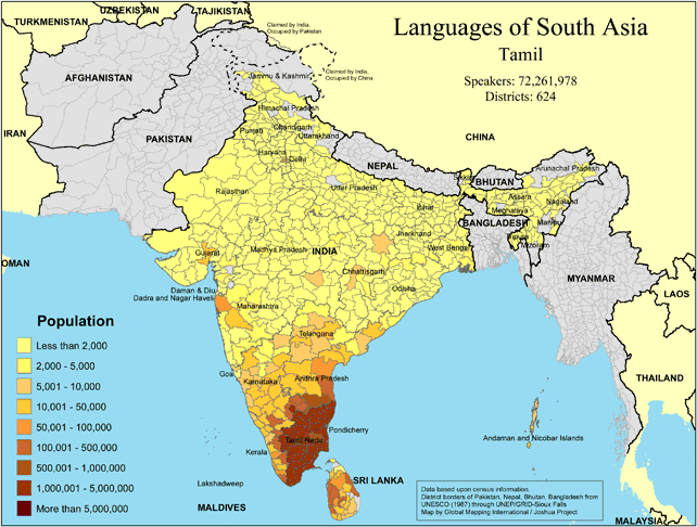 |
·Type: Maps ·Map Date: 2018 ·Data Source: Omid, based on census information ·Partners: OMID 2018 ·Size: 8.27 by 11.69 inches, landscape ·Categories: Type :: Maps Continent/Region :: Asia Country :: India Country :: Sri Lanka Country :: Nepal Country :: Bangladesh Country :: Bhutan Partners :: OMID Collection :: Map Collections :: OMID 2018 Topic :: Language and Translation |
... more info
|
|
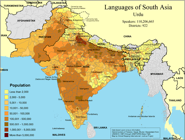 |
·Type: Maps ·Map Date: 2018 ·Data Source: Omid, based on census information ·Partners: OMID 2018 ·Size: 8.27 by 11.69 inches, landscape ·Categories: Type :: Maps Continent/Region :: Asia Country :: Pakistan Country :: India Country :: Nepal Country :: Bangladesh Partners :: OMID Collection :: Map Collections :: OMID 2018 Topic :: Language and Translation |
... more info
|
|
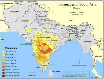 |
·Type: Maps ·Map Date: February 2008 ·Data Source: Census Information, UNESCO (1987) through UNEP/GRID-Sioux Falls ·Producer: Global Mapping International and The Joshua Project ·Size: 11.7 by 8.27 inches, landscape ·Categories: Type :: Maps Continent/Region :: Asia Topic :: Demography Country :: Nepal Country :: India Country :: Bangladesh Partners :: Global Mapping International Topic :: Language and Translation Partners :: Joshua Project |
... more info
Max: 1
|
|
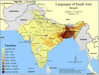 |
·Type: Maps ·Map Date: February 2008 ·Data Source: Census Information, UNESCO (1987) through UNEP/GRID-Sioux Falls ·Producer: Global Mapping International and The Joshua Project ·Size: 11.7 by 8.27 inches, landscape ·Categories: Type :: Maps Continent/Region :: Asia Topic :: Demography Country :: Nepal Country :: India Country :: Bangladesh Country :: Pakistan Partners :: Global Mapping International Topic :: Language and Translation Partners ::... |
... more info
Max: 1
|
|
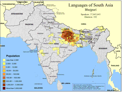 |
·Type: Maps ·Map Date: February 2008 ·Data Source: Census Information, UNESCO (1987) through UNEP/GRID-Sioux Falls ·Producer: Global Mapping International and The Joshua Project ·Size: 11.7 by 8.27 inches, landscape ·Categories: Type :: Maps Continent/Region :: Asia Topic :: Demography Country :: Nepal Country :: India Country :: Bangladesh Partners :: Global Mapping International Topic :: Language and Translation Partners :: Joshua Project |
... more info
Max: 1
|
|
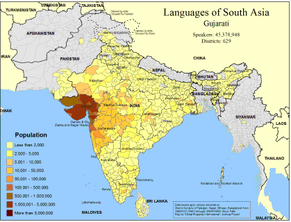 |
·Type: Maps ·Map Date: February 2008 ·Data Source: Census Information, UNESCO (1987) through UNEP/GRID-Sioux Falls ·Producer: Global Mapping International and The Joshua Project ·Size: 11.7 by 8.27 inches, landscape ·Categories: Type :: Maps Country :: Sri Lanka Continent/Region :: Asia Topic :: Demography Country :: Nepal Country :: India Country :: Bangladesh Country :: Pakistan Partners :: Global Mapping International Topic :: Language and... |
... more info
Max: 1
|
|
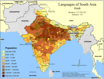 |
·Type: Maps ·Map Date: February 2008 ·Data Source: Census Information, UNESCO (1987) through UNEP/GRID-Sioux Falls ·Producer: Global Mapping International and The Joshua Project ·Size: 11.7 by 8.27 inches, landscape ·Categories: Type :: Maps Continent/Region :: Asia Topic :: Demography Country :: Nepal Country :: India Country :: Bangladesh Partners :: Global Mapping International Topic :: Language and Translation Partners :: Joshua Project |
... more info
Max: 1
|
|
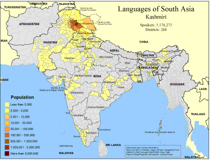 |
·Type: Maps ·Map Date: February 2008 ·Data Source: Census Information, UNESCO (1987) through UNEP/GRID-Sioux Falls ·Producer: Global Mapping International and The Joshua Project ·Size: 11.7 by 8.27 inches, landscape ·Categories: Type :: Maps Continent/Region :: Asia Topic :: Demography Country :: India Country :: Bangladesh Country :: Pakistan Partners :: Global Mapping International Topic :: Language and Translation Partners :: Joshua Project |
... more info
Max: 1
|
|
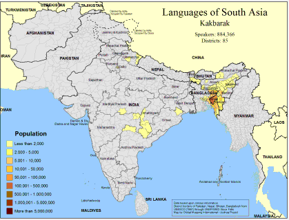 |
·Type: Maps ·Map Date: February 2008 ·Data Source: Census Information, UNESCO (1987) through UNEP/GRID-Sioux Falls ·Producer: Global Mapping International and The Joshua Project ·Size: 11.7 by 8.27 inches, landscape ·Categories: Type :: Maps Continent/Region :: Asia Topic :: Demography Country :: India Country :: Bangladesh Partners :: Global Mapping International Topic :: Language and Translation Partners :: Joshua Project |
... more info
Max: 1
|
|