| Product Image |
Resource Name- |
Price |
Manufacturer |
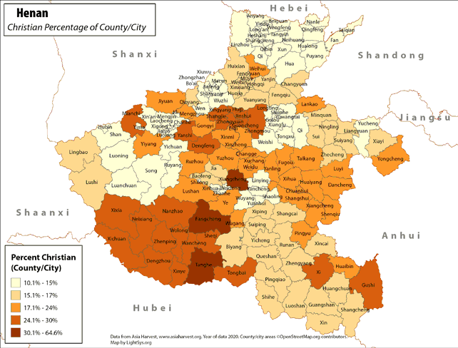 |
· Type: Maps · Map Date: 2018 · Data Source: Asia Harvest; county/city areas © OpenStreetMap contributors, http://www.openstreetmap.org/copyright. Data available under the Open Database License · Partners: LightSys Technology Services · Collection: Projects 2018 · Size: 8½ x 11 inches, landscape · Categories: Type :: Maps Continent/Region :: Asia Country :: China Topic :: Statistical Topic :: Religions,... |
... more info
|
|
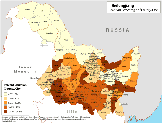 |
· Type: Maps · Map Date: 2019 · Data Source: Asia Harvest; county/city areas © OpenStreetMap contributors, http://www.openstreetmap.org/copyright. Data available under the Open Database License · Partners: LightSys Technology Services · Collection: Projects 2019 · Size: 8½ x 11 inches, landscape · Categories: Type :: Maps Continent/Region :: Asia Country :: China Topic :: Statistical Topic :: Religions,... |
... more info
|
|
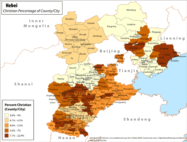 |
· Type: Maps · Map Date: 2019 · Data Source: Asia Harvest; county/city areas © OpenStreetMap contributors, http://www.openstreetmap.org/copyright. Data available under the Open Database License · Partners: LightSys Technology Services · Collection: Projects 2019 · Size: 8½ x 11 inches, landscape · Categories: Type :: Maps Continent/Region :: Asia Country :: China Topic :: Statistical Topic :: Religions,... |
... more info
Max: 1
|
|
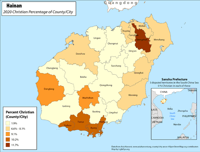 |
· Type: Maps · Map Date: 2018 · Data Source: Asia Harvest; county/city areas © OpenStreetMap contributors, http://www.openstreetmap.org/copyright. Data available under the Open Database License · Partners: LightSys Technology Services · Collection: Projects 2018 · Size: 8½ x 11 inches, landscape · Categories: Type :: Maps Continent/Region :: Asia Country :: China Topic :: Statistical Topic :: Religions,... |
... more info
|
|
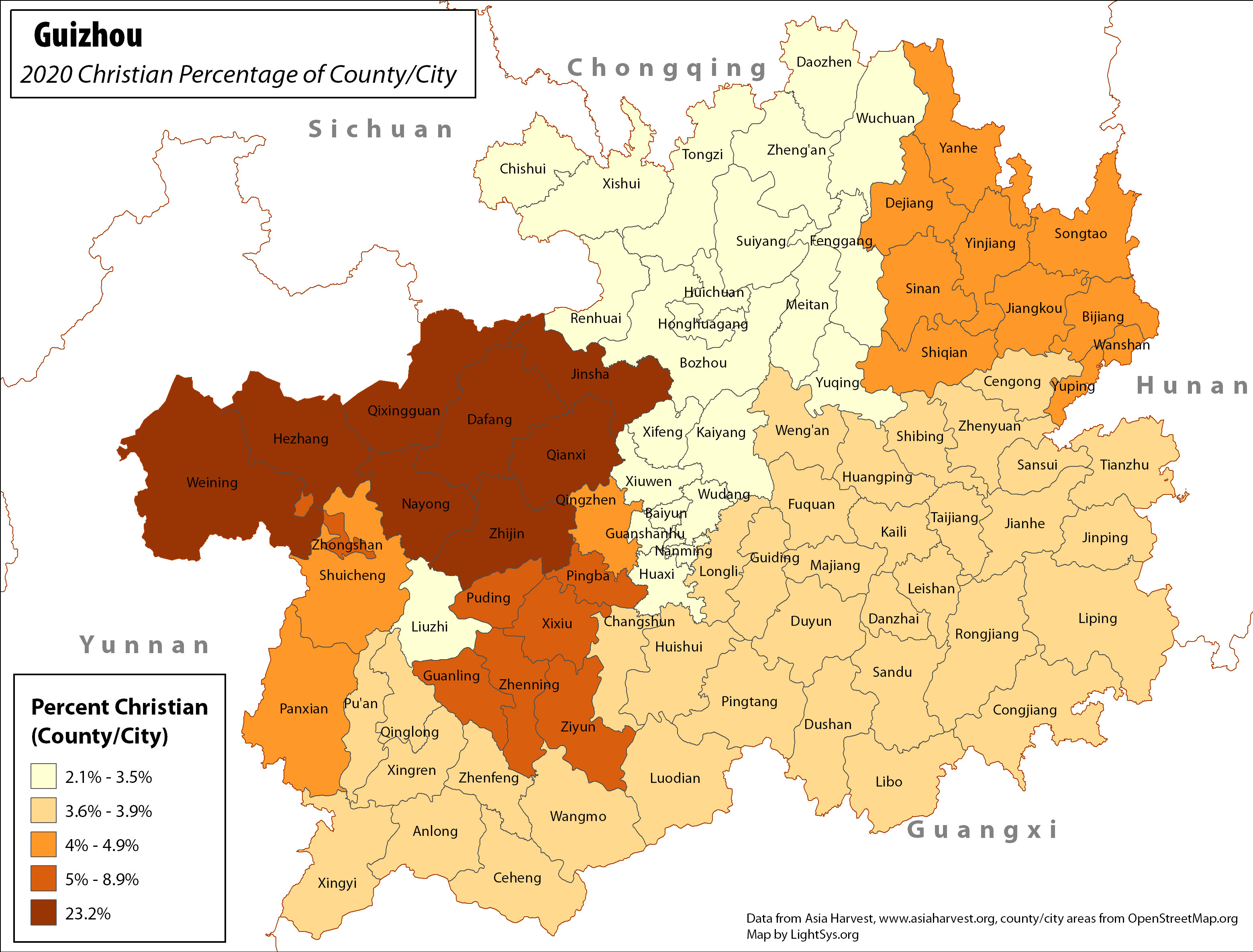 |
· Type: Maps · Map Date: 2017 · Data Source: Asia Harvest; county/city areas © OpenStreetMap contributors, http://www.openstreetmap.org/copyright. Data available under the Open Database License · Producer: LightSys Technology Services · Collection: Projects 2017 · Size: 8½ x 11 inches, landscape · Categories: Type :: Maps Continent/Region :: Asia Country :: China Topic :: Statistical Topic :: Religions,... |
... more info
Max: 1
|
|
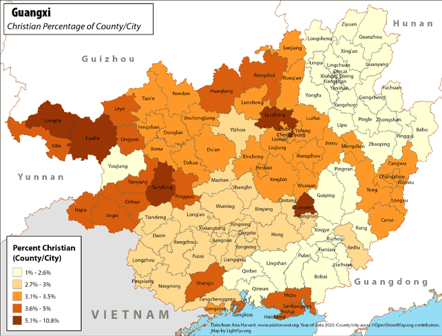 |
· Type: Maps · Map Date: 2018 · Data Source: Asia Harvest; county/city areas © OpenStreetMap contributors, http://www.openstreetmap.org/copyright. Data available under the Open Database License · Partners: LightSys Technology Services · Collection: Projects 2018 · Size: 8½ x 11 inches, landscape · Categories: Type :: Maps Continent/Region :: Asia Country :: China Topic :: Statistical Topic :: Religions,... |
... more info
|
|
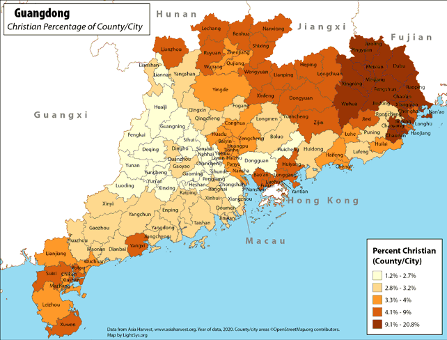 |
· Type: Maps · Map Date: 2018 · Data Source: Asia Harvest; county/city areas © OpenStreetMap contributors, http://www.openstreetmap.org/copyright. Data available under the Open Database License · Partners: LightSys Technology Services · Collection: Projects 2018 · Size: 8½ x 11 inches, landscape · Categories: Type :: Maps Continent/Region :: Asia Country :: China Topic :: Statistical Topic :: Religions,... |
... more info
Max: 1
|
|
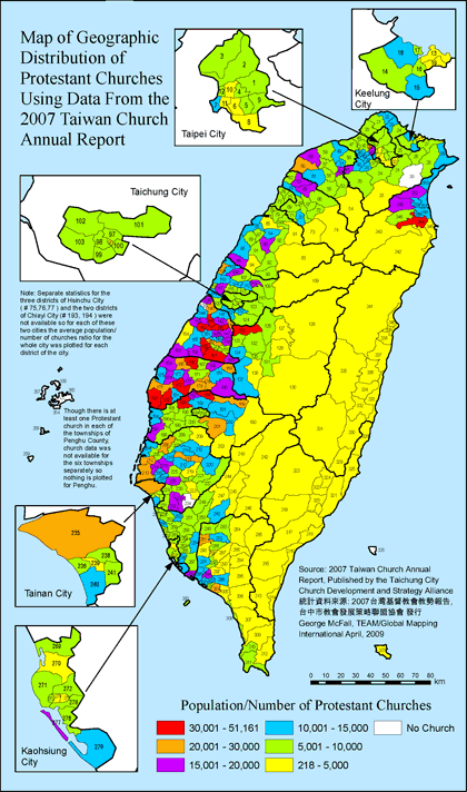 |
·Type: Maps ·Full title: Map of Geographic Distribution of Protestant Churches Using Data From the 2007 Taiwan Church Annual Report ·Map Date: April 2009 ·Data Source: 2007 Taiwan Church Annual Report ·Producer: George McFall ·Collection: Taiwan Church ·Size: 8½ by 14 inches, portrait ·Categories: Type :: Maps Country :: Taiwan Topic :: Religions, Christianity :: Adherents, Churches, and Denoms Collection :: TEAM-George McFall ::... |
... more info
Max: 1
|
|
 |
·Type: Maps ·Full title: Geographic Distribution of Protestant Churches In the Region of Taiwan's Taipei City ·Map Date: June 2009 ·Data Source: 2007 Taiwan Church Annual Report ·Producer: George McFall ·Collection: Taiwan Church ·Size: 8½ by 14 inches, portrait ·Categories: Type :: Maps Country :: Taiwan Topic :: Religions, Christianity :: Adherents, Churches, and Denoms Collection :: TEAM-George McFall :: Taiwan Church Partners... |
... more info
Max: 1
|
|
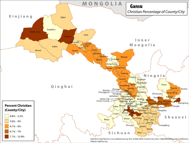 |
· Type: Maps · Map Date: 2019 · Data Source: Asia Harvest; county/city areas © OpenStreetMap contributors, http://www.openstreetmap.org/copyright. Data available under the Open Database License · Partners: LightSys Technology Services · Collection: Projects 2019 · Size: 8½ x 11 inches, landscape · Categories: Type :: Maps Continent/Region :: Asia Country :: China Topic :: Statistical Topic :: Religions,... |
... more info
|
|
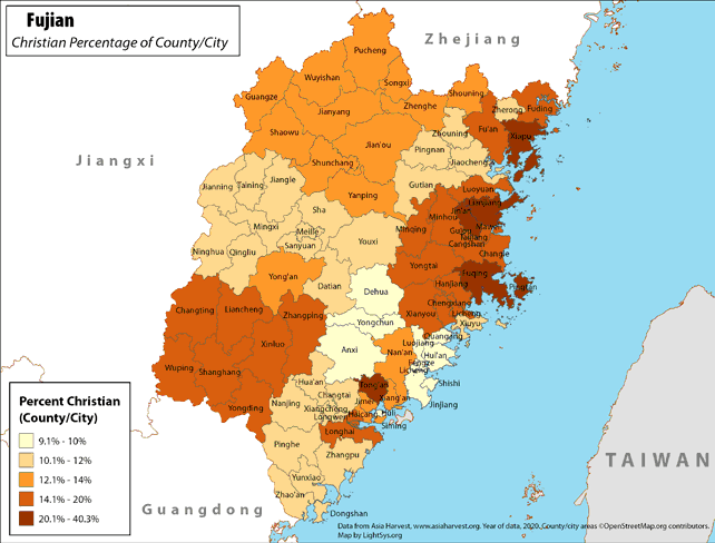 |
· Type: Maps · Map Date: 2018 · Data Source: Asia Harvest; county/city areas © OpenStreetMap contributors, http://www.openstreetmap.org/copyright. Data available under the Open Database License · Partners: LightSys Technology Services · Collection: Projects 2018 · Size: 8½ x 11 inches, landscape · Categories: Type :: Maps Continent/Region :: Asia Country :: China Topic :: Statistical Topic :: Religions,... |
... more info
Max: 1
|
|
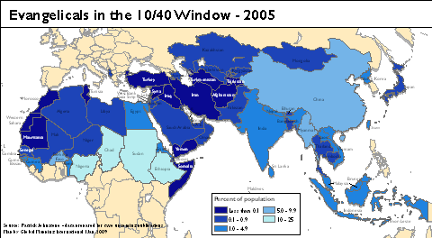 |
·Type: Maps ·Map Date: January 2009 ·Data Source: Patrick Johnstone ·Producer: Global Mapping International ·Collection: Projects 2009 ·Size: 10.2 by 5.7 inches, landscape ·Categories: Type :: Maps Topic :: Concepts Partners :: Global Mapping International Topic :: Religions, Christianity :: Adherents, Churches, and Denoms Continent/Region :: 10/40 Window Collection :: GMI Map Collections :: Projects 2009 |
... more info
Max: 1
|
|
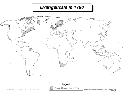 |
·Type: Maps ·Description: Evangelicals in 1790 ·Map Date: 2002 ·Producer: Global Mapping International ·Collection: Worldwide Perspectives (WV 2002) ·Size: 8½ x 11 Inches, landscape ·Categories: Type :: Maps Collection :: GMI Map Collections :: Worldwide Perspectives (WV 2002) Continent/Region :: World Topic :: History Partners :: Global Mapping International Topic :: Religions, Christianity :: Adherents, Churches, and Denoms |
... more info
Max: 1
|
|
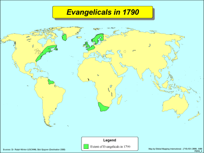 |
·Type: Maps ·Description: Evangelicals in 1790 ·Map Date: 2002 ·Producer: Global Mapping International ·Collection: Worldwide Perspectives (WV 2002) ·Size: 8½ x 11 Inches, landscape ·Categories: Type :: Maps Collection :: GMI Map Collections :: Worldwide Perspectives (WV 2002) Continent/Region :: World Topic :: History Partners :: Global Mapping International Topic :: Religions, Christianity :: Adherents, Churches, and Denoms |
... more info
Max: 1
|
|
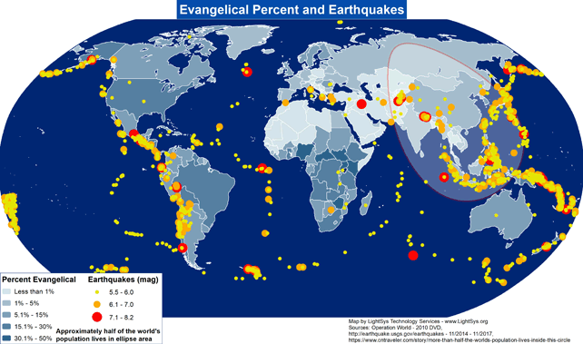 |
· Type: Maps · Map Date: 2017 · Data Source: Operation World (2010) DVD, http://earthquake.usgs.gov/earthquakes - 11/2014 – 11/2017, https://www.cntraveler.com/story/more-than-half-the-worlds-population-lives-inside-this-circle · Producer: Global Mapping International · Collection: Projects 2017 · Size: 8½ x 11 inches, landscape · Categories: Type :: Maps Continent/Region :: World Topic :: Demography... |
... more info
Max: 1
|
|
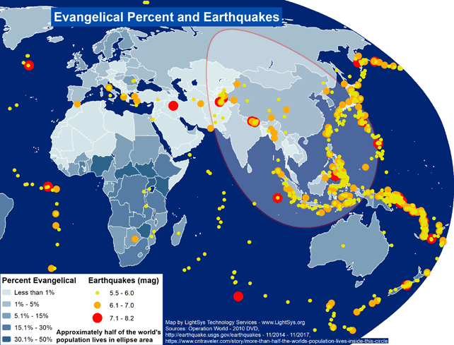 |
· Type: Maps · Map Date: 2017 · Data Source: Operation World (2010) DVD, http://earthquake.usgs.gov/earthquakes - 11/2014 – 11/2017, https://www.cntraveler.com/story/more-than-half-the-worlds-population-lives-inside-this-circle · Producer: Global Mapping International · Collection: Projects 2017 · Size: 8½ x 11 inches, landscape · Categories: Type :: Maps Continent/Region :: Asia Topic :: Demography... |
... more info
Max: 1
|
|
 |
·Type: Maps ·Map Date: 2001 ·Data Source: Operation World ·Producer: Global Mapping International ·Collection: Intro to Mission (WorldVue 2002) ·Size: 8½ x 11 Inches, landscape ·Categories: Type :: Maps Collection :: GMI Map Collections :: Intro to Mission (WorldVue 2002) Partners :: Global Mapping International Topic :: Religions, Christianity :: Adherents, Churches, and Denoms |
... more info
Max: 1
|
|
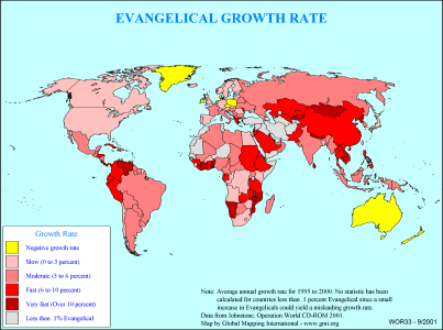 |
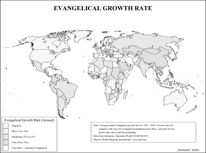
·Type: Maps ·Description: Country level divisions of the evangelical growth rate ·Map Date: 2000 ·Producer: Global Mapping International ·Collection: General World Maps (WV 2002) ·Size: 8½ x 11 Inches, landscape ·Categories: Type :: Maps Collection :: GMI Map Collections :: General World Maps (WV 2002) Continent/Region :: World Topic :: Statistical Partners :: Global Mapping International Topic :: Religions, Christianity :: Adherents,... |
... more info
Max: 1
|
|
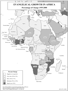 |
·Type: Maps ·Description: Growth rate of Evangelicals in Africa ·Map Date: 2002 ·Producer: Global Mapping International ·Collection: Reaching Africa (WorldVue 2002) ·Size: 8½ x 11 Inches, portrait ·Categories: Type :: Maps Collection :: GMI Map Collections :: Reaching Africa (WorldVue 2002) Continent/Region :: Africa Topic :: Statistical Partners :: Global Mapping International Topic :: Religions, Christianity :: Adherents, Churches, and... |
... more info
Max: 1
|
|
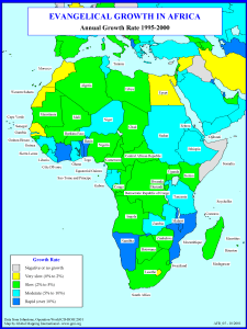 |
·Type: Maps ·Description: Growth rate of Evangelicals in Africa ·Map Date: 2001 ·Producer: Global Mapping International ·Collection: Reaching Africa (WorldVue 2002) ·Size: 8½ x 11 Inches, portrait ·Categories: Type :: Maps Collection :: GMI Map Collections :: Reaching Africa (WorldVue 2002) Continent/Region :: Africa Topic :: Statistical Partners :: Global Mapping International Topic :: Religions, Christianity :: Adherents, Churches, and... |
... more info
Max: 1
|
|
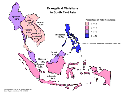 |
·Type: Maps ·Description: Country level divisions of Evangelical Christians in Southeast Asi ·Map Date: 1998 ·Producer: Global Mapping International ·Collection: Focus South East Asia (WV 2002) ·Size: 8½ x 11 Inches, landscape ·Categories: Type :: Maps Collection :: GMI Map Collections :: Focus South East Asia (WV 2002) Continent/Region :: Asia Topic :: Statistical Partners :: Global Mapping International Topic :: Religions, Christianity... |
... more info
Max: 1
|
|
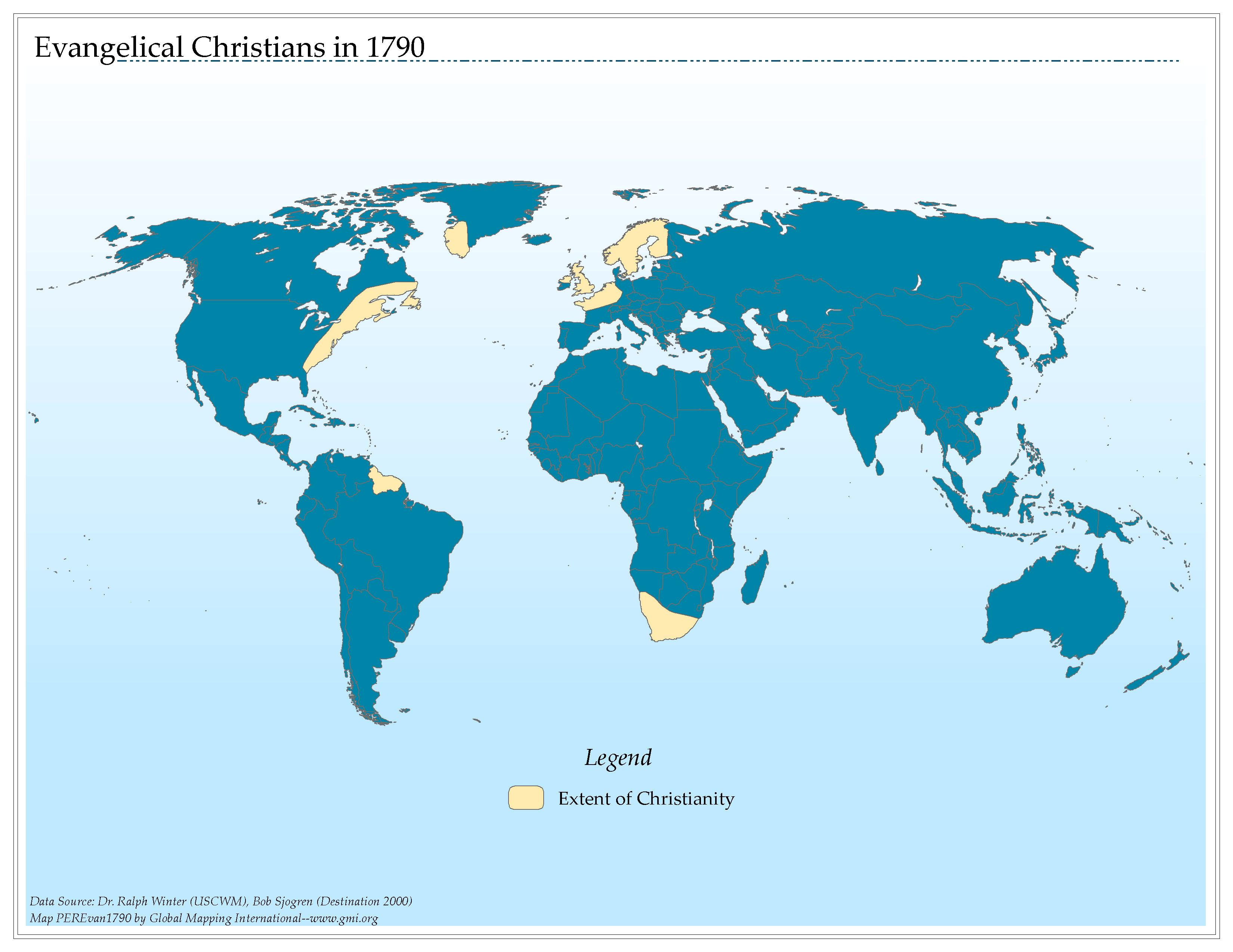 |
·Type: Maps ·Map Date: 2006 ·Data Source: Dr. Ralph Winter (USCWM), Bob Sjogren (Destination 2000) ·Producer: Global Mapping International ·Collection: Worldwide Perspectives GMMS 2007 ·Size: 8½ x 11 inches, landscape ·Categories: Type :: Maps Continent/Region :: World Topic :: History Partners :: Global Mapping International Collection :: GMI Map Collections :: Worldwide Perspectives GMMS 2007 Topic :: Religions, Christianity ::... |
... more info
Max: 1
|
|
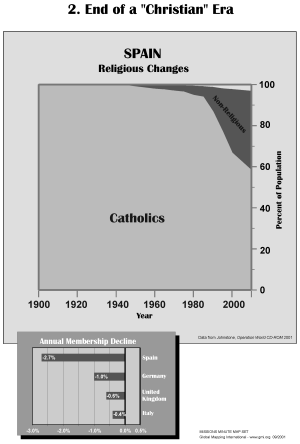 |
·Type: Maps ·Description: End of a "Christian" Era ·Map Date: 2002 ·Producer: Global Mapping International ·Collection: Missions Minute (WorldVue 2002) ·Size: 8½ x 11 Inches, portrait ·Categories: Type :: Maps Collection :: GMI Map Collections :: Missions Minute (WorldVue 2002) Topic :: Statistical Topic :: Strategy Topic :: Concepts Topic :: History Type :: Graphs Country :: Spain Partners :: Global Mapping International Topic ::... |
... more info
Max: 1
|
|
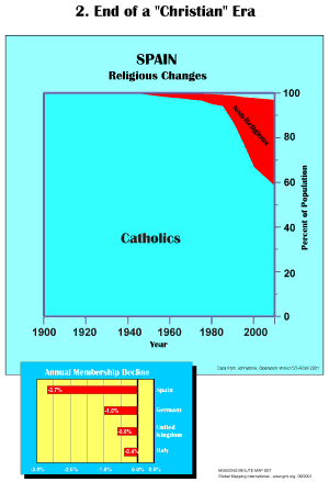 |
·Type: Maps ·Description: End of a "Christian" Era ·Map Date: 2001 ·Producer: Global Mapping International ·Collection: Missions Minute (WorldVue 2002) ·Size: 8½ x 11 Inches, portrait ·Categories: Type :: Maps Collection :: GMI Map Collections :: Missions Minute (WorldVue 2002) Topic :: Statistical Topic :: Strategy Topic :: Concepts Topic :: History Type :: Graphs Country :: Spain Partners :: Global Mapping International Topic ::... |
... more info
Max: 1
|
|
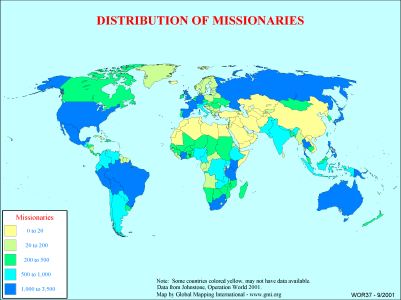 |
·Type: Maps ·Description: Country level distributions of missionaries ·Map Date: 2000 ·Producer: Global Mapping International ·Collection: General World Maps (WV 2002) ·Size: 8½ x 11 Inches, landscape ·Categories: Type :: Maps Collection :: GMI Map Collections :: General World Maps (WV 2002) Continent/Region :: World Topic :: Statistical Partners :: Global Mapping International Topic :: Religions, Christianity :: Adherents, Churches, and... |
... more info
Max: 1
|
|